Management responses
Management responses are the actions or initiatives undertaken to protect, maintain and restore environmental assets, as well as those that prevent, mitigate or adapt to changes in the environment. They are generally developed in reaction to the observed or anticipated pressures and impacts, or the state of the environment. They act in a multitude of ways, either individually or, more often, in concert with one another to bring about environmental change.
Applicable management responses related to include:
Legislation
-
Biodiscovery involves the collection of small amounts of native biological resources (e.g. plants, animals, fungi and micro-organisms that are native to Australia) and subsequent screening to identify bioactive compounds that may be used for commercial purposes (e.g. pharmaceuticals and insecticides). In Queensland, biodiscovery activities are regulated under the Biodiscovery Act 2004.
This Act’s main purposes are to:
- ensure biodiscovery entities act appropriately when accessing or using traditional knowledge for biodiscovery;
- facilitate access by biodiscovery entities to minimal quantities of native biological material for biodiscovery on or in State land or Queensland waters;
- encourage the development of value-added biodiscovery within the State;
- ensure that the State, for the benefit of all Queenslanders, obtains a fair and equitable share of the benefits of biodiscovery;
- and ensure biodiscovery enhances knowledge of Queensland’s biological diversity, promoting the conservation and sustainable use of native biological resources.
Under the Act, individuals and organisations engaging in biodiscovery must:
- obtain a collection authority before accessing native biological material from State land or Queensland waters;
- negotiate and enter into a Benefit-Sharing Agreement with the State before commencing biodiscovery activities;
- when traditional knowledge is involved, take all reasonable and practical measures to ensure its use is governed by an agreement with the custodians of that knowledge, as introduced in the 2020 reforms;
- comply with the Traditional Knowledge Code of Practice and the Traditional Knowledge Guidelines.
More information:
-
All Queenslanders have a general biosecurity obligation under Queensland's Biosecurity Act 2014.
This general obligation means everyone is responsible for managing biosecurity risks that are:
- under their control
- that they know about or should reasonably be expected to know about.
Under the general biosecurity obligation, individuals and organisations whose activities pose a biosecurity risk must:
- take all reasonable and practical steps to prevent or minimise each biosecurity risk
- minimise the likelihood of causing a biosecurity event and limit the consequences if such an event is caused
- prevent or minimise the harmful effects a risk could have, and not do anything that might make any harmful effects worse.
More information:
-
Under the Queensland Environmental Offsets Act 2014, an environmental offset is an activity undertaken to counterbalance a significant residual impact of development on a prescribed environmental matter.
Unlike mitigation actions, which occur on-site as part of the project (e.g. relocation of an individual plant or animal), environmental offsets occur at another location containing the same environmental values.
The environmental offsets framework
Queensland’s environmental offsets framework provides a structure for delivering, measuring, monitoring and securing environmental offsets.
Features of the framework include:
- Options for a land-based offset, a financial payment to a secured offsets fund or a combination of both.
- The offset funds, managed by the department or local governments, deliver strategic outcomes with advice from an independent committee.
- An option to meet an offset obligation using a proponent-driven offset on land owned by the proponent or a third party.
- Staging offset delivery for larger projects to ensure significant residual impacts are counterbalanced and allowing offset credits or debits to be carried over to later stages of the project.
- Opportunities for landholders to become involved in environmental offset delivery by expressions of interest (free of charge) or applying for an Advanced Offset after surveying ecological conditions.
- Mapping of Strategic Offset Investment Corridors, providing a high-level indication of places potentially suitable for environmental offsets.
Offsets Register
An Environmental Offsets Register lists offsets approved by the Queensland Government since 1 July 2014. Maintained by the department, the register includes information about:
- authorities granted an offset condition for matters of state environmental significance
- financial payments
- land-based offsets
- advanced offsets
- expression of interest areas.
The register is publicly available on the Queensland Government’s website and regularly updated.
More information:
-
The Environmental Protection Act 1994 (EP Act) is a key element of Queensland’s environmental legal system. Its objective is to protect Queensland’s environment while allowing for development that improves the total quality of life, both now and in the future, in a way that maintains ecological processes (ecologically sustainable development).
The EP Act and its subordinate legislation provides a range of tools to enable this objective to be met. These tools range from providing for a licensing system for environmentally relevant activities (ERAs) (called an environmental authority) through to response tools such as environmental enforcement orders.
Under the EP Act, environmental protection policies may be developed to cover specific aspects of the environment. There are approved policies for the air environment, acoustic environment, and for water and wetland biodiversity.
Table 1: Administration of activities under the EP Act by relevant administration
Activities under the EP Act DETSI DPI DNRMMRRD Local
GovernmentChanges to the EP Act and subordinate legislation ✓ Administration of Environmentally Relevant Activities (ERAs) ✓ ✓ ✓ ✓ Contaminated land management ✓ Reports about contraventions of the EP Act ✓ ✓ ✓ Actions taken to enforce the EP Act ✓ ✓ ✓ Legislation amendments
All Queenslanders have a ‘general environmental duty’ (GED) under the Environmental Protection Act 1994.
In addition, specific activities require an approval from the administering authority in order to carry out those activities. These activities can be characterised as:
The chief executive for the EP Act must report on the administration of the Act each year. See below link for further information.
Key legislative amendments are also detailed on the department’s website.
More information:
-
Fish Habitat Areas (FHAs) are declared under the Fisheries Act 1994. Queensland has 72 declared FHAs along its coast. This network provides long-term protection of high-quality fish habitats from the physical impacts of coastal development. This protection is essential for sustaining recreational, commercial and Indigenous fisheries.
The primary purpose of the Fisheries Act (and its Regulations) is to provide for the use, conservation and enhancement of the community’s fisheries resources and fish habitats in a way that seeks to:
(a) apply and balance the principles of ecologically sustainable development
(b) promote ecologically sustainable development.
Together with the Planning Act 2016 (the state’s overarching development assessment legislation), the Fisheries Act (and its Regulations) provides a legislative framework for the assessment of development works in declared FHAs that balances the principles of ecologically sustainable development and community access to fisheries resources, with the continued protection of fish habitats.
FHA legislation is supported by operational policies for managing FHAs and for the selection, assessment, declaration and review of FHAs. There is also a statutory Code of Practice for pest control in FHAs.
More information:
-
The primary objective of the Great Barrier Reef Marine Park Act 1975 is to provide for the long term protection and conservation of the environment, biodiversity, and heritage values of the Great Barrier Reef Region. The Act provides for:
- the establishment of the Great Barrier Reef Marine Park Authority
- a framework for the planning and management of the Marine Park through zoning plans, plans of management and a system of permissions.
Subordinate to the Great Barrier Reef Marine Park Act 1975, the Great Barrier Reef Marine Park Zoning Plan 2003 (Zoning Plan) is the primary planning instrument for the conservation and management of the Marine Park.
The Zoning Plan considers the world heritage values of the marine park. It aims, with other management mechanisms, to:
- conserve the biodiversity of the Great Barrier Reef ecosystem within a network of highly protected zones
- provide opportunities for the ecologically sustainable use of the Reef and access to the Great Barrier Reef Region by current and future generations.
More information:
-
The koala (Phascolarctos cinereus) was uplisted from vulnerable in Southeast Queensland to endangered across its range under state and Commonwealth legislation in 2022.
On 7 February 2020, the Nature Conservation and Other Legislation (Koala Protection) Amendment Regulation 2020 took effect.
The development regulations introduced in 2020 protect important areas in which koalas live in Southeast Queensland (SEQ) by:
- prohibiting the clearing of koala habitat in koala priority areas
- regulating the clearing of koala habitat in koala habitat areas via development approvals.
More information:
-
The Marine Parks Act 2004 (the Act) provides for the conservation of Queensland’s marine environment by implementing a comprehensive range of management strategies, including:
- the declaration of marine parks
- the establishment of zones and designated areas, including highly protected areas within marine parks.
These management arrangements are formalised through gazetted zoning plans and, where necessary, the development of management plans.
The Act aims to achieve a coordinated and integrated approach with other environmental conservation legislation. It recognises the cultural, economic, environmental and social relationships between marine parks and their adjacent lands and waters.
International and national responsibilities
Australia’s international responsibilities and intergovernmental agreements are essential considerations in park management. Marine parks extend across areas adjacent to the Queensland coast under the control of the Commonwealth and Queensland Governments. Both governments have agreed that, as far as practicable in managing marine parks, state legislation will be consistent with the relevant Commonwealth legislation. This agreement is critical in the Great Barrier Reef region, where complementary measures support the management of this significant area.
Queensland marine parks
Marine parks are multiple-use areas that provide for various activities and visitor opportunities, e.g. fishing, tourism, education, research and coastal infrastructure. The zoning plans prescribed under the Act describe where the types of uses can occur and various other management measures.
Three marine parks have been declared under the Act, and corresponding zoning plans have been established:
- The Great Barrier Reef Coast Marine Park
- The Great Sandy Marine Park
- The Moreton Bay Marine Park.
Along with the Commonwealth Great Barrier Reef Marine Park, approximately 99% of the east coast of Queensland sits within a marine park.
The plans and regulations that support the Act are:
- Marine Parks (Declaration) Regulation 2006
- Marine Parks (Great Barrier Reef Coast) Zoning Plan 2004
- Marine Parks (Great Sandy) Zoning Plan 2024
- Marine Parks (Moreton Bay) Zoning Plan 2019
- Marine Parks Regulation 2017.
Annual reporting on the administration of the Act supports vital communication and accountability. From 2020 to 2024, there have been three annual reports. The findings are below.
Amendments
Instrument 2020-21 2021-22 2022-23 Marine Parks Act 2024 0 1 1 Marine Parks (Declaration) Regulation 2006 0 0 0 Marine Parks (Great Barrier Reef Coast) Zoning Plan 2004 1 0 0 Marine Parks (Great Sandy) Zoning Plan 2017 1 0 0 Marine Parks (Moreton Bay) Zoning Plan 2019 2 1 0 Marine Parks Regulation 2017 1 2 0 Approved management plans
No new management plans for marine park areas were approved in the reporting period.
Authorities
Category issued Current @30/06/21 2020-21 2021-22 2022-23 State -Commonwealth joint marine park permissions 5236 1767 1448 1415 State-only marine park authorities 742 169 126 215 Commercial activity agreements 31 2 6 11 Offences and enforcement
Category 2020-21 2021-22 2022-23 Penalty infringement notices Number issued 130 78 72 Number withdrawn 4 2 4 Number of court elects 4 3 5 Number of reviews 5 3 3 Formal investigations Number completed 2 1 2 Prosecutions Number progressed 0 N/A 1 Number of matters finalised 3 3 1 Accreditations
Marine park Purpose 2020-21 2021-22 2022-23 Moreton Bay Marine Park Oyster Industry 1 1 1 Great Sandy Marine Park Aquaculture 1 1 1 Great Barrier Reef Coast Marine Park Protection and conservation of identified values 0 0 1 Traditional use of marine resources 9 10 10 Limited impact research 8 8 8 Legislative provisions
Marine Park Provision 2020-21 2021-22 2022-23 Moreton Bay Marine Park Special activity notice 7 7 7 Regulatory notice 3 3 3 Great Barrier Reef Coast Marine Park Special activity notice 1 1 1 Regulatory notice 4 4 4 More information:
-
The Nature Conservation Act 1992 (NC Act) provides a legislative basis for nature conservation through the dedication, declaration and management of protected areas and the protection of native wildlife and its habitat.
The NC Act aims to achieve nature conservation while allowing for the involvement of First Nations peoples in the management of protected areas through an integrated and comprehensive conservation strategy for the whole state. It provides the framework for:
- research
- community education
- dedicating, declaring, and managing protected areas
- protecting native wildlife and its habitat.
The NC Act also provides for making subordinate legislation, including regulations, notices, and conservation plans. The list of primary legislation and subordinate legislation in force as of 30 June 2024:
- Nature Conservation Act 1992
- Nature Conservation (Animals) Regulation 2020
- Nature Conservation (Estuarine Crocodile) Conservation Plan 2018
- Nature Conservation (Forest Reserves) Regulation 2000
- Nature Conservation (Koala) Conservation Plan 2017
- Nature Conservation (Macropod) Conservation Plan 2017
- Nature Conservation (Plants) Regulation 2020
- Nature Conservation (Protected Areas Management) Regulation 2017
- Nature Conservation (Protected Areas) Regulation 1994
Legislation changes
Several amendments were made to the NC Act and its subordinate legislation during the reporting period. These amendments included the following.
- Declaration of the state’s first special wildlife reserve, a class of private protected area with national park level protections.
- Dedication and declaration of protected areas, including new protected areas and transfers from the forest reserve tenure.
- New provisions enabling beekeeping to continue in certain national parks until 31 December 2044.
- Updates to identity card requirements for authorised officers and police officers and to offences for impersonating or obstructing these officers.
- Amendments to the conservation status of a range of flora and fauna species
- Guidelines for releasing rehabilitated koalas and changes to the definition of prescribed natural habitat.
- Removal of the chief executive’s ability to grant damage mitigation permits for the lethal take of flying foxes for commercial crop protection.
- Provision of fee waivers for exceptional circumstances, including COVID-19 and Tropical Cyclone Jasper.
- Updates to vehicle-related offences, including increased penalties to improve consistency with transport legislation.
- Updates to protected area schedules, including trustees on conservation parks and resource reserves, listings of permitted uses on national parks, prescribing of apiary areas and places where fishing and crabbing are permitted.
- Repeal of the Nature Conservation (Administration) Regulation 2017 and relocation of relevant provisions into the Nature Conservation (Animals) Regulation 2020, Nature Conservation (Plants) Regulation 2020, and the Nature Conservation (Protected Areas Management) Regulation 2017.
- Updates to reflect culturally appropriate language and the change of Fraser Island’s name to K’gari.
- A range of additional administrative and consequential amendments.
Management Framework
The Act provides the legislative framework to manage protected areas so that their natural and cultural values are protected and conserved while recognising other compatible uses.
Similarly, outside of protected areas, most native plants and animals are protected under the Act and managed under a legislative framework designed to promote the continuation of viable and sustainable populations in the wild.
Specific tools for managing protected areas and wildlife outside of these areas include:
- park management plans and statements
- conservation agreements and management programs
- regulatory notices
- licences and permits for the taking or use of wildlife
- individual conservation plans or recovery plans for some species.
Annual reporting
Annual reporting on the administration of the Act supports vital communication and accountability. From 2020 to 2024, there have been four annual reports, which outline:
- the legislative amendments for the financial year
- management tools
- details on the authorities granted under the NC Act
- appointment of new conservation officers and Indigenous Land and Sea Rangers authorised to exercise powers under the NC Act the compliance and enforcement activities undertaken during the financial year.
More information:
- Nature Conservation Act 1992
- Annual Report on the administration of the Nature Conservation Act 1992 for 1 July 2023 to 30 June 2024
- Annual Report on the administration of the Nature Conservation Act 1992-1 July 2022 to 30 June 2023
- Report on the administration of the Nature Conservation Act 1992 (1 July 2021 to 30 June 2022)
- Report on the administration of the Nature Conservation Act 1992 (1 July 2020 to 30 June 2021)
-
A statutory review of the Reef protection regulations commenced in February 2023 and was completed in February 2024.
The Statutory review of the Reef protection regulations report can be found on the Queensland Parliament website.
Purpose and scope
The purpose of the review was to assess the extent to which the Reef protection regulations have been effective in reducing pollutant loads (specifically dissolved inorganic nitrogen and sediment suspended in the water).
To do this, the review looked at whether practices had improved and explored if there were any challenges with implementation.
The review did not include broader matters such as water quality targets or water quality science. These issues were outside the scope set under the Environmental Protection Act 1994 and are being considered as part of the review of the Reef 2050 Water Quality Improvement Plan.
Review results
The review did not recommend any changes to the Reef protection regulations, but did find that they:
- have resulted in practice change
- are an influential part of a suite of practice change interventions being implemented to generally address poor Reef water quality (including both agricultural and industrial sources of sediment and nutrient loads)
- are complemented by targeted investment and delivery of voluntary practice change programs and projects and this enhances progress.
The review identified opportunities to improve engagement with the regulated community and to continue to assist them to comply with and go beyond the regulated standards.
The opportunities will be considered as part of the Queensland Reef Water Quality Program.
The Reef protection regulations are only one part of a suite of tools to drive water quality improvements for the Great Barrier Reef.
The Queensland Government is committed to working with landholders and investing in industry-led best management practice programs to improve water quality.
The Queensland Government’s Queensland Reef Water Quality Program has committed $124.8 million over five years to 2025–2026 to support the agricultural industry.
More information:
-
The Convention on Wetlands, commonly called the Ramsar Convention, is an intergovernmental treaty that provides the framework for national action and international cooperation for the conservation and wise use of wetlands and their resources.
Queensland has five Ramsar sites recognised as being wetlands of international significance under this convention:
- Moreton Bay
- Bowling Green Bay
- Currawinya Lakes
- Great Sandy Strait
- Shoalwater Bay and Corio Bay.
The Environment Protection and Biodiversity Conservation Act 1999 (Cth) (EPBC Act) establishes a framework for protecting and managing Ramsar wetlands in Australia, including Australian Ramsar management principles relevant to preparing Ramsar site management plans.
Queensland is responsible for:
- the nomination of its Ramsar sites
- the development and maintenance of site documentation
- ensuring the maintenance of the ecological character of the sites
- notification of any changes or likely changes to the ecological character of the sites.
The appropriate landholders and land managers are responsible for managing wetlands and their associated flora and fauna. Many groups engage in Ramsar management activities, including natural resource management groups, community groups, Traditional Custodians, and local and state governments.
In addition to managing Ramsar sites, the Queensland Government is responsible for promoting the wise use of all wetlands.
Targets
- All Ramsar site documentation (Ramsar Information Sheets) is up to date.
- Ramsar management principles and values are incorporated into management, policy and planning documents.
- Knowledge gaps are identified and addressed and the information is used in management.
- The values and conservation of Ramsar sites and all wetlands are promoted through education, website materials and events.
Outcomes
- Conservation measures, rehabilitation, and monitoring ensure that the ecological character of the sites is maintained.
- Queensland, Commonwealth and Local Governments, natural resource management groups, Traditional Custodians, researchers, industry and other community representatives work together to manage the Ramsar sites in a coordinated manner.
- The ecological character of all Ramsar wetlands is maintained.
More information:
-
Native vegetation is critical for:
- maintaining biodiversity
- preventing land degradation
- reducing Queensland’s carbon emissions.
In Queensland, clearing is regulated through the vegetation management framework. It applies to most land tenures, including freehold land, Indigenous land, leasehold land and occupational licences under the Land Act 1994 (Qld). The Queensland Government monitors clearing to ensure people comply with the laws.
The Vegetation Management Act 1999 regulates the clearing of vegetation in a way that:
- conserves remnant vegetation
- ensures clearing does not cause land degradation
- prevents loss of biodiversity
- maintains ecological processes
- reduces greenhouse gas emissions
- allows for sustainable land use.
Clearing trends
- The 2021-22 annual Statewide Landcover and Trees Study (SLATS) reported that clearing has fallen 52% since 2018-19, with most clearing in areas not regulated by the Vegetation Management Act 1999 (Qld).
- Clearing of regulated vegetation reduced by 64% between 2018-19 to 2021-22.
The Queensland Government strengthened Queensland’s vegetation management laws, implementing nation-leading protections to:
- increase the resilience of the Great Barrier Reef
- reduce carbon emissions
- ensure the framework is supported by the latest scientific advice.
Reducing emissions
Queensland’s vegetation management laws have contributed significantly to Australia’s reduction of carbon dioxide emissions due to the declined rates of tree clearing in Queensland since the laws started.
According to Australia’s National Greenhouse Accounts (ANGA), since Queensland’s vegetation management laws were introduced, the Land Use, Land Use Change & Forestry (LULUCF) sector emissions have decreased by around 131% from 2000 to 2022.
The LULUCF sector includes carbon emissions from tree clearing and other land management practices. Collectively, these measures have resulted in the LULUCF sector contributing equivalent to all of Queensland’s net emissions reductions since 2005, putting the state on track for the target of a 75% reduction by 2035.
We continue to investigate and implement improvements to the vegetation management framework, including:
- Accepted development vegetation clearing codes were updated in 2020 and 2023 to include additional measures for the protection of koalas and reflect the latest scientific advice.
- In 2022, an independent panel of experts was established to review the factors behind land clearing identified in the 2018-2019 Statewide Land and Trees Study report. In late 2023 the Queensland government accepted (in full and in principle) the panel’s ten recommendations.
- A $9.8 million investment over four years by the Queensland Government to enhance compliance with the vegetation management framework and reduce unexplained clearing through increased engagement and compliance.
- In 2023, a new certified Vegetation Management Regional Ecosystem Description Database (VMREDD), making it easier for landholders to find relevant information about regional ecosystems and their class.
- In 2023, the Vegetation Management Regulation was remade to improve its accuracy and efficiency.
- Scientific updates to vegetation management maps were released annually to ensure consistency with the latest available science and provide landholder certainty about mapped vegetation on their land.
More information:
Policy and Programs
-
Overview
Aquatic Conservation Assessments (ACAs) are designed to identify wetlands’ conservation values (not social or economic ones) for environmental decision-making.
The Aquatic Biodiversity Assessment Mapping Method (AquaBAMM) is used to develop ACAs.
The department developed AquaBAMM as a comprehensive method for assessing wetlands’ conservation values, identifying relative wetland conservation values within a specified study area (usually a catchment) using available data and expert opinion.
AquaBAMM results provide a powerful decision support tool that is easily interrogated through a Geographic Information System (GIS).
Updates to ACAs across Queensland provide the most accurate wetland conservation values, helping to:
- prioritise protection strategies
- support aquatic ecosystem rehabilitation
- inform investment decisions, development and impact assessments
- guide resource management.
These results are instrumental in determining matters of state environmental significance, which are considered in decision-making under environmental, planning and offset legislation.
Targets
- ACAs riverine and non-riverine assessments are conducted and updated for Queensland.
- Spatial data and reporting are available and accessible for environmental decision-making.
Outcomes
Freshwater ACAs have been completed and released for all of Queensland.
- Three assessments have been completed and released since 2020:
- Southern Gulf Catchments (2020),
- Queensland Murray-Darling and Bulloo Basins (2022),
- Wide Bay-Burnett Great Barrier Reef Connecting Catchments (2024).
- Assessments for the Fitzroy and Burdekin Great Barrier Reef Connecting Catchments are underway.
- The GIS results, reports and outcomes for all ACAs are available online to assist with decision making.
Study area
Riverine (R)
Non-riverine (NR)
Estuarine (E)
Marine (M) and Springs (SP) metadataACA version
Release date
Burnett River1
R
1.1
18/07/2006
1.1
09/12/2012
R, NR
1.1
30/06/2018
R, NR
1.1
31/08/2020
1.1
30/10/2009
1.1
30/06/2016
1.3
15/04/2011
2.1
08/12/2022
1.1
09/10/2015
1.1
12/11/2010
2.1
20/05/2024
Aquatic Conservation Assessment - Queensland - combined layer 5
R, NR
2.1
14/06/2024
ACA related assessment (i.e. assessment has similarities; however, does not strictly adhere to the AquaBAMM)
E, M
1.1
30/03/2019
1 The Burnett River Riverine ACA is superseded by the Wide Bay-Burnett riverine ACA, which includes coverage of the Burnett River catchment. The Burnett River Riverine ACA remains displayed in the table above due being the first ACA study.
2 The Great Barrier Reef Study ACAs include the following catchments: Baffle, Barron, Belyando, Black, Bowen, Boyne, Burdekin lower, Burdekin upper, Burnett, Calliope, Comet, Curtis Island, Daintree, Dawson, Don, Fitzroy, Haughton, Herbert, Hinchinbrook Island, Isaac, Johnstone, Mackenzie, Mossman, Mulgrave-Russell, Murray, Nogoa, O’Connell, Pioneer, Plane, Proserpine, Ross, Shoalwater, Styx, Tully and Waterpark. The Baffle Creek Riverine ACA is superseded by the Great Barrier Reef riverine and non-riverine . Results for the Baffle catchment are superseded by the results completed for the Baffle as part of the Wide Bay-Burnett Great Barrier Reef Connecting Catchments (v2.1) assessment.
3 The Queensland Murray-Darling and Bulloo Basins ACA includes the following catchments: Border Rivers, Condamine-Balonne, Maranoa, Moonie Basin, Wallam, Warrego, Paroo and Bulloo. This version supersedes the Bulloo assessment that was part of the Lake Eyre and Bulloo Basins ACA (2016), the Condamine River ACA (2009) and the Queensland Murray-Darling Basin ACA (2011).
4 The results for the Baffle catchment supersede the results completed for the Baffle as part of the Great Barrier Reef Catchments Riverine ACA (v1.1), Great Barrier Reef Catchments Non-riverine ACA (v1.3), and Burnett River ACA (v1.1)
5 Combined non-riverine layer for the following areas: Southern Gulf Catchments, Eastern Gulf of Carpentaria, Southeast Queensland, Lake Eyre and Bulloo Basins, Cape York Catchments, Queensland Murray-Darling and Bulloo Basins, Great Barrier Reef and Wide Bay-Burnett Catchments
6 The Baffle to Fitzroy Coast Common Conservation Values assessment, is not an ACA produced under the AquaBAMM. However, criteria adopted were derived from the AquaBAMM criterion.More information:
-
Carbon farming presents an opportunity to help restore balance by:
- using land-based plant life and wetlands to naturally reabsorb excess carbon dioxide
- changing land management practices to reduce the amount of greenhouse gases emitted from human activities.
Trees and other parts of our environment can reabsorb some of the extra carbon dioxide, but the capacity of the Earth to do this is limited.
Carbon farming land management seek to:
- reduce carbon emissions from human activities
- increase carbon sequestration in carbon sinks
- provide landholders with a range of benefits, such as increased natural capital and an alternate source of income.
Many Queensland landholders are already earning an income from carbon projects. The Australian Government Clean Energy Regulator provides a register that can be searched to see where registered carbon projects are occurring in Queensland. Alternatively, carbon credits can be retained by landholders and surrendered to offset on-farm emissions. We are growing the carbon farming industry in Queensland through the Land Restoration Fund (LRF).

Carbon farming key concepts
There are several key concepts that all landholders should be familiar with when considering undertaking a carbon farming project. Please refer to the Clean Energy Regulator for detailed information. All Land Restoration Fund (LRF) projects must also abide by these requirements.
Carbon farming methods
All Land Restoration Fund (LRF) projects must follow an approved Australian Carbon Credit Unit Scheme method to generate Australian Carbon Credit Units (ACCUs). The methods explain how to carry out a carbon farming project and measure the resulting reductions in emissions. The methods ensure the emission reductions are real and in addition to business-as-usual operations.
Each method specifies:
- the activities to conduct
- how to measure carbon abatement
- the monitoring, record keeping and reporting requirements.
The list of eligible carbon farming methods for LRF investment will be specific to each investment round.
At December 2024, there are three types of land sector carbon methods that can generate ACCUs:
- Agricultural methods
- Vegetation methods
- Savanna fire management methods
More information:
-
Estuarine crocodiles are a protected species in Queensland, listed as vulnerable under the Nature Conservation Act 1992 (NC Act). Queensland’s crocodile management program takes a holistic approach that seeks to protect public safety and ensure the ongoing conservation of the species across its range.
The department’s Crocodile Management Program comprises:
- a public safety education program known as ‘Be Crocwise’
- a framework for the management of crocodiles in the wild (including the removal of ‘problem crocodiles’) based on a series of zones under the Queensland Crocodile Management Plan)
- scientific research and monitoring that informs future crocodile management.
Crocodile sightings
In 2020, the department developed a free app, QWildlife, enabling the public to submit crocodile sightings to the department via their smartphones or tablets. They can also submit via the department’s website or by calling 1300 130 372. These sightings help keep track of the movements and behaviour of crocodiles. Departmental wildlife rangers investigate every sighting report received. In 2024 the department received 1,335 crocodile sighting reports and removed 93 problem crocodiles.
Research reports
Two recently published research reports provide important information to help improve estuarine crocodile conservation and public safety outcomes:
- Estuarine Crocodile Population Monitoring in Queensland (1979–2019) Technical Report (2022)
- The genetic structure and connectivity of the estuarine crocodile (Crocodylus porosus) in Queensland 2018–2020 (2023).
A third report, Modelling population dynamics of estuarine crocodiles on Queensland’s northern populated east coast (2023), found that:
- the crocodile population between Cooktown and Ingham was not at risk of extinction in the foreseeable future unless there was a significant change in crocodile management practices
- continuing the current removal rate was likely to be a safe strategy from a species conservation standpoint and an effective public safety management strategy.
The report findings will help inform future approaches to estuarine crocodile management.
More information:
-
The Australian Government funds a crown-of-thorns starfish management program, which involves manually injecting starfish to protect coral cover on priority reefs, particularly prime tourism sites.
A highly collaborative effort, the Crown-of-thorns Starfish Control Program is run in partnership with the Great Barrier Reef Foundation and Reef and Rainforest Research Centre along with supporting government agencies, industry partners and contractors.
Reef managers, researchers, Program contractors, and the tourism industry and operators have worked in partnership over the past decade to deliver crown-of-thorns control operations at increasing spatial scales.
The following information is drawn from the Great Barrier Reef Outlook Report 2024.
The Crown-of-thorns Starfish Control Program (Control Program) aims to protect coral across a network of high-value reefs by suppressing starfish numbers to sustainable levels. It has become a core management action to enhance the Great Barrier Reef’s resilience under a changing climate.
There is strong evidence that the Control Program effectively reduces the severity of outbreaks and protects coral across entire reefs and regions timely culling can effectively suppress outbreaks to the point where coral growth greatly exceeds losses from predation.
Importantly, these protected coral communities continue to replenish local and downstream reefs with coral larvae, supporting the recovery and adaptation of the Region’s reefs after major disturbance events. The Control Program:
- delivers crown-of-thorns starfish suppression and coral protection outcomes across hundreds of reefs
- augments the benefits of zoning plans and other management actions to enhance the resilience of the Reef and the industries that rely on it.
The risk level associated with crown-of-thorns starfish outbreaks has reduced from very high in 2019 to high in 2024. This reduction is driven by management actions, including proactive surveillance and targeted culling by the Control Program, coupled with an improved understanding of the program’s effectiveness. Benefits have also accrued from:
- past establishment of no-take zones, which protect starfish predators and enhance recovery from outbreaks
- additional protection measures for predators implemented through fisheries reforms.
More information:
- Crown-of-thorns Starfish - Case Study
- Crown-of-thorns starfish control program | Reef Authority
- Outlook Report 2024: Section 8.3.1 Coral reef habitats
- Outlook Report 2024: Section: 9.3.5 Trends in risks to the Region’s values
- Matthews, S.A., Williamson, D.H., Beeden, R., Emslie, M.J., Abom, R.T.M., et al. 2024, Protecting Great Barrier Reef resilience through effective management of crown-of-thorns starfish outbreaks, PLoS One 19(4): e0298073.
- Outlook Report 2024: 1.4.2 Assessment of trends and confidence
- Outlook Report 2024: 1.4.1 Assessment grades and grading statements
-
The purpose of the Environmental Protection (Water and Wetland Biodiversity) Policy 2019 (EPP Water and Wetland Biodiversity) is to achieve the objectives of the Environmental Protection Act 1994 (EP Act) in protecting Queensland’s water environment while allowing for ecologically sustainable development.
Environmental values and water quality objectives
The EPP Water and Wetland Biodiversity sets out the environmental values (EVs) and water quality objectives (WQOs) for all Queensland waters.
- EVs define the uses of water by aquatic ecosystems and humans (e.g. drinking water, irrigation, aquaculture, recreation).
- WQOs define the objectives for the water’s physical, chemical and biological characteristics (e.g. nitrogen content, dissolved oxygen, turbidity, toxicants, fish).
- Locally derived EVs and WQO are being progressively determined for Queensland waters to inform environmental decision-making (see the map below).
Where the Queensland Government have derived the EVs and WQOs for specific Queensland waters, they are set out in Schedule 1 of the EPP Water and Wetland Biodiversity. This schedule is a part of the legislation. Therefore, planners and managers must consider it when making decisions about waters and water quality.
EVs and WQOs can be used in several ways in legislative and non-legislative decision-making. Once scheduled, they inform:
- planning and decision-making for development under the EP Act (e.g. point source environmentally relevant activities)
- local government planning and decision-making for urban land development under the State Planning Policy (Water Quality State Interest - Planning Act)
- best practice management approaches to address diffuse emissions from rural lands
- development of report cards on aquatic ecosystem health
- catchment-scale management planning and decisions by non-legislative Regional NRM bodies.
The most recent waters included in Schedule 1 are the South East Queensland Basins; Burdekin, Haughton and Don Basins and Mackay Whitsunday Basins, approved in 2022.

-
The Great Barrier Reef Blueprint for Climate Resilience and Adaptation (Blueprint 2030) is the next chapter in addressing the challenge of climate change impacts on the Reef.
The Blueprint 2030 will help the Reef Authority deliver on the objectives of the Great Barrier Reef Marine Park Act 1975 (Cth) to protect and conserve the Reef now and into the future. It is a strategic roadmap to strengthen Reef resilience and a key deliverable of the Australian and Queensland government’s Reef 2050 Plan, the overarching framework for protecting and managing the Great Barrier Reef to 2050.
At the heart of Blueprint 2030 are five strategic goals that will drive how the Great Barrier Reef Marine Park Authority adapts its management under a changing climate to progressively and effectively respond to the risks identified in the Outlook Report.
More information:
-
Every five years, the Great Barrier Reef Marine Park Authority prepares the Great Barrier Reef Outlook Report, which examines the Reef’s health, pressures, management and long-term outlook.
Protection and management issues are complex, given the wide range of activities in the Region and its Catchment and the variety of effects these activities can have on the Reef. Effective management of the Great Barrier Reef Region depends on partnerships between:
- government
- Traditional Owners
- industry
- community.
For the Outlook Report 2024, five independent assessors assessed the effectiveness of existing measures to manage and protect the Region’s ecosystem and heritage values.
The following information is drawn from the Great Barrier Reef Outlook Report 2024 ’s ‘Existing protection and management’ chapter. The independent report is available on the Reef Authority website.
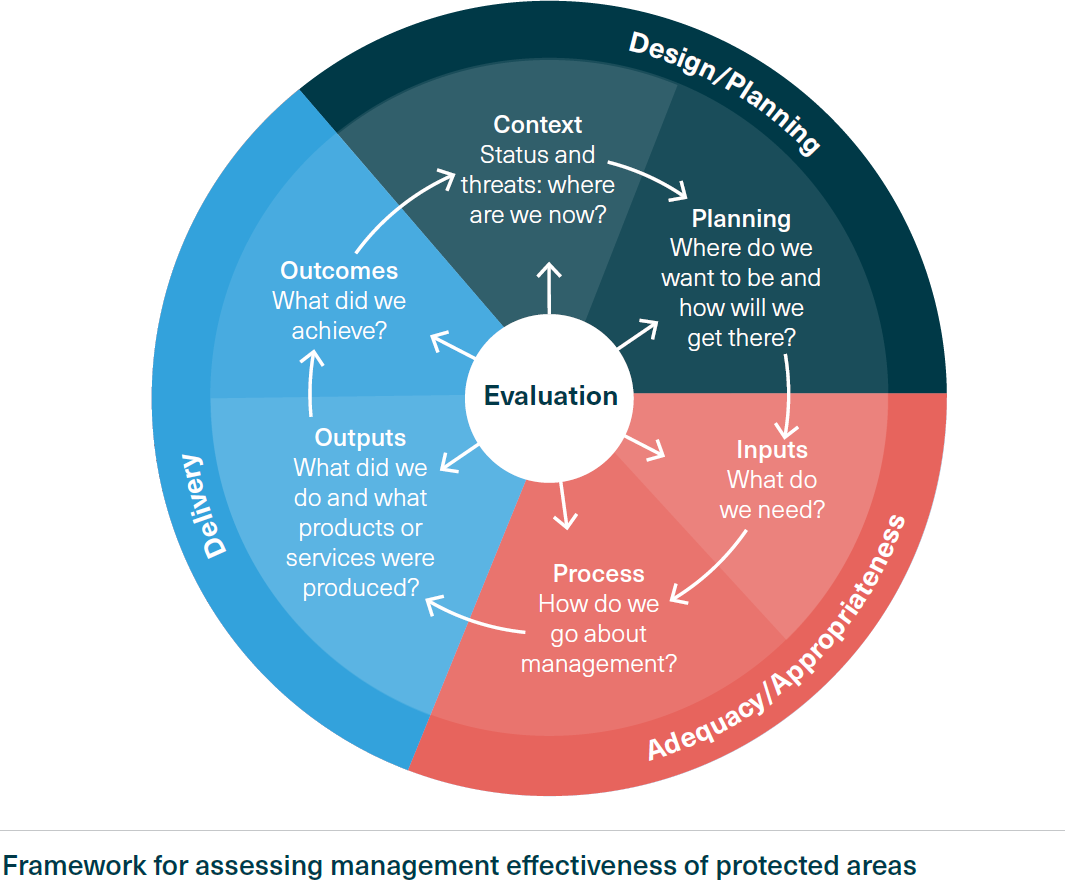
Effective management of the Region is a complex task, given the range of threats and their variation across space and time. The management effectiveness assessment focused on the six elements of the management framework:
- context
- planning
- inputs
- processes
- outputs
- outcomes.
The assessment addressed 14 broad management topics and considered the activities of relevant Australian and Queensland government agencies and other contributing partners.
Framework for assessing management effectiveness of protected areas
Effective management is a closed loop, where issues are considered, plans are made, resources are expanded, processes are followed, and products and services are delivered, all leading to outcomes that address the issues.
 Key current and future initiatives to improve the Reef’s values and support resilience. Source: Great Barrier Reef Outlook Report 2024


Management effectiveness overall
The 2024 assessment found the Region continues to be well-managed overall, with over 80% of the elements across the management topics considered effective or mostly effective. Notable management improvements since 2019 include enhanced funding and planning initiatives through the Reef 2050 Plan and Queensland Sustainable Fisheries Strategy 2017-2027. However, effectiveness declines have occurred for some management aspects since 2019.
Managing direct use
Direct use of the Region is generally well-managed, likely due to the lower complexity involved (compared with managing external factors) and the maturity of the management systems.
- Well-resourced planning and management systems are in place to support sustainable commercial marine tourism activities.
- Defence activities and shipping are both considered well-regulated and effectively managed.
- Port authorities are typically well-resourced and provide a high degree of environmental management for port activities, which carry with them a range of risks.
- Fishing management outcomes remain only partially effective in 2024; however, significant reform is being implemented through the Queensland Sustainable Fisheries Strategy.
- Traditional use of marine resources and management of Sea Country have been assisted by Traditional Use of Marine Resources Agreements. The ‘Agreement to Partner’ is a key step in progressing Traditional Owner aspirations for the Reef.
- Research activities and recreational use are generally considered well-managed and low=risk, but knowledge gaps remain regarding both the cumulative impacts of research activities and in the changing nature and scale of recreational use in the Region.
Managing external factors
External factors influencing the Region include:
- climate change
- coastal development
- land-based runoff.
Management is considered the weakest for climate change and coastal development. Nevertheless, climate change has seen the most improvement in management effectiveness since 2019, including enhanced management of climate change risks and advances in climate change policy at national, state and local levels.
Notable policy advances in climate change management include:
- the introduction of the Climate Change Act 2022 (Commonwealth)
- the inclusion of a specific work area under the Reef 2050 Plan that articulates clear goals and strategic actions towards achieving emission reduction targets.
Despite this progress in policy, the management of the Reef regarding climate change remains subject to significant challenges.
Coastal development activities are managed within a multi-level governance system. Planning systems are well-developed, but integration and coordination between land and marine-based planning is a significant challenge. While improvements have occurred in the management of land-based runoff, along with a general reduction in pollutant loads since 2019, the 2025 water quality targets are not expected to be met.
Managing to protect the Region’s values
Management that protects the Region’s biodiversity, heritage, and community benefit values is mostly effective. However, inputs to management of heritage and community benefits have not improved from partially effective, and achievement of heritage and biodiversity outcomes has been trending downward since 2019.
Results
Criteria and component summaries Grade and trend Understanding of context:
Context was the strongest element in the management effectiveness framework. Managers generally had a good and improving understanding of the values relevant to each management topic (although this was weakest for heritage and coastal development), national and international influences, and key stakeholders. While condition and trends for each topic were generally known, threats and their impacts were less well known. Specifically, the cumulative and consequential impacts of threats were generally poorly understood across most management topics.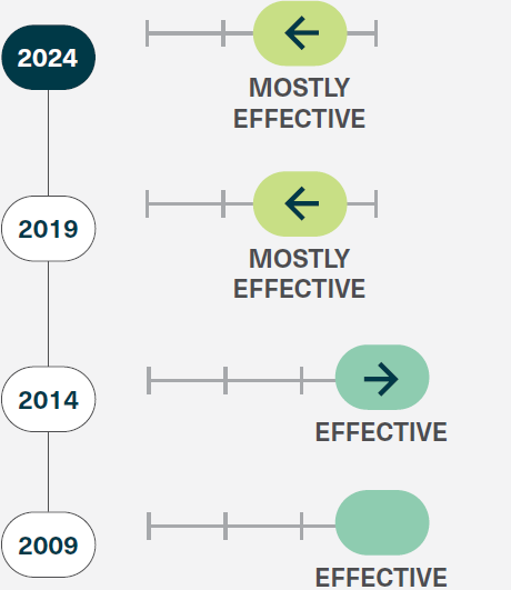
Criteria and component summaries Grade and trend Planning:
Planning performed well in relation to overall management effectiveness with no topics being graded as ineffective or partly effective. Reef planning is spatially complex, spanning marine and terrestrial environments and requires effective coordination of actors and systems. Management topic-specific legislation, plans and policies apply across multiple spatial scales (international to local) and sectors. The Reef 2050 Plan is the overarching plan addressing most of the key elements required for effective Reef management and the Intergovernmental Agreement sets the framework for joint coordination of planning and management. Strengths of planning include certainty around where activity can occur (Zoning Plan), setting clear actions and planning consistency across jurisdictions (Reef 2050 Plan).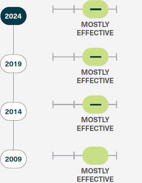
Criteria and component summaries Grade and trend Financial, staffing and information inputs:
Inputs for most topics were graded as mostly effective, with four topics rated as partially effective (climate change, coastal development, heritage and community benefits). Funding in general, has increased across most topics with improvements in the funding for water quality improvement, Reef management and conservation, Reef restoration and adaptation, and strengthening partnerships and stewardship. Innovative funding strategies are being developed (for example the Reef Recovery 2030 fundraising campaign by the Reef Trust Partnership). The adequacy of human resourcing within all managing organisations was the weakest of all topics and was partly impacted by COVID-19. Data inputs overall are effective, although there are gaps in Indigenous heritage and historic heritage information. Provisioning of adequate data sharing platforms was also identified as a key deficit particularly for research efforts. Non-government involvement was also mostly effective reflecting the strong level of community engagement and interest in the Reef.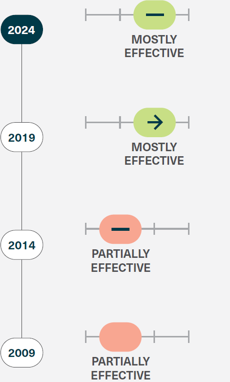
Criteria and component summaries Grade and trend Management systems, processes and governance:
Processes for many topics remained stable since 2019 but there were declining trends for community benefits, coastal development, land-based runoff and research. Strengths were identified in relation to engagement with stakeholders and the integration of biophysical and socio-economic information into decision-making. Weaknesses relate to the integration of Indigenous and heritage information, consideration of cumulative and consequential impacts, and limitations in governance systems (such as gaps in effective engagement of local governments and other key actors, coordination among jurisdictions and siloed approaches). Declines in governance effectiveness reflect the scale and complexity of matters that need to be addressed as part of Reef management and point to the need for more substantial institutional redesign or rethinking of principles and values underpinning governance goals.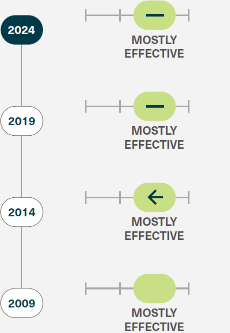
Criteria and component summaries Grade and trend Delivery of outputs:
Outputs remained stable for the majority of topics. Upward grade changes, such as that for climate change, reflect the improvement in the planning system. Declines across research, traditional use of marine resources and land-based runoff are a result of resourcing issues during the period of COVID-19 restrictions, which impacted the outputs that could be delivered. While the delivery of outputs was generally strong, especially in terms of delivering products and related actions, there were weaknesses in achievement of results against objectives. This in part reflects the absence of clear objectives for some management topics or misalignment of outputs with expected objectives.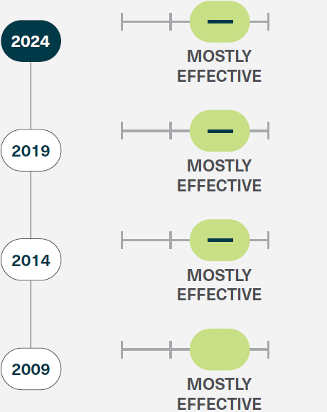
Criteria and component summaries Grade and trend Achievement of outcomes:
The achievement of outcomes was the weakest of all elements of the management effectiveness framework. However, results were highly variable across the management topics with most direct use areas performing well but external factors and overall values performing poorly. The outcomes for five topics were graded as partially effective for biodiversity, coastal development, fishing, heritage and land-based runoff. The management outcomes for climate change were graded as ineffective. The relatively poor achievement of outcomes partly reflects a range of external influences on the Reef (such as bleaching events and climate change stressors) but also reflects an increasing understanding of the extent of existing impacts. Outcomes for climate change and biodiversity were poor across a number of indicators, including the protection of values, reduction of threats, and environmental, economic and social sustainability. Poor outcomes for heritage reflect the poor and deteriorating condition of many Indigenous heritage values and many historic heritage sites, especially underwater cultural heritage. However, there was evidence of effective partnerships across most of the management topics.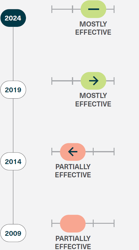
-
The Gurra Gurra Framework 2020–2026 was launched in April 2020 by the then Department of Environment and Science (now renamed the Department of the Environment, Tourism, Science and Innovation), reflecting the need for the Queensland Government to be culturally capable, integrated and respectful in our relationship with First Nations people. The Framework takes a holistic approach to improve processes and outcomes with ten initiatives driving change.
Since its inception, a number of outcomes have been delivered using the principles of the Gurra Gurra Framework 2020-2026 as a compass. A small sample of these include:
- Supported Traditional Owners to develop and launch the Reef 2050 Traditional Owner Implementation Plan
- Continued to deliver the co-designed Aboriginal and Torres Strait Islands Local Government, Environmental Services Support Program, to optimise the environmental performance of waste and wastewater infrastructure to improve healthier outcomes for communities
- Released the Queensland First Nations World Heritage Strategy
- Coordinated the renaming of Fraser Island to K’gari and celebrated the 30th anniversary of the island being added to the World Heritage List
- Delivered co-designed Management Plans or Statements including the Noosa Area Management Plan with Kabi Kabi people, the iconic Raine Island National Park (Scientific) Management Statement with Wuthathi people and Meriam Nation people and Currawinya National Park Management Plan with Budjiti people
- Created the First National Park (Aboriginal Land) tenure in Queensland with the Waanyi People for Boodjamulla (Lawn HIll) National Park
- Finalised the “Stronger Together” Queensland Parks and Wildlife Services and Partnerships Branch Indigenous Employment and Retention Strategy 2025-2029.
Organisational reform continues to be a focus across every part of our business operation and Gurra Gurra serves as foundational guide to put Country and People at the centre of all the work that we do. To ensure continued improvement, the Department undertook a mid-way review in late 2023 of the Gurra Gurra Framework, to assess if its impact and reach was meeting its desired outcomes. The review, undertaken independently by an external First Nations organisation, identified six key areas for improvement. The Department is committed to working on implementing these recommendations to ensure that the Framework is uplifted to achieve its full potential.
More information:
-
The Environmental Protection (Water and Wetland Biodiversity) Policy 2019 (EPP Water and Wetland Biodiversity), legislation under the Environmental Protection Act 1994, establishes Healthy Waters Management Plans (HWMPs) as a planning mechanism to improve the quality of Queensland waters.
Using consultation and the best available science, HWMPs identify:
- environmental values
- water quality objectives
- catchment-based management actions.
HWMPs have been developed for all Queensland Murray–Darling Basin catchments. For these catchments, the HWMPs fulfil EPP Water and Wetland Biodiversity requirements and Australian Government water quality planning provisions under the Murray-Darling Basin Plan 2012.
In 2016, the Warrego, Paroo, Bulloo and Nebine Basins HWMP was approved. The Condamine HWMP, Queensland Border Rivers–Moonie HWMP and Maranoa–Balonne HWMP were approved in 2019. These plans identify the key risks to water quality across the Queensland Murray–Darling Basin and highlight potential management responses to address the risks.
HWMPs are broader than water quality as they protect aquatic ecosystems by specifying water quality objectives for indicators such as macroinvertebrates, fish, riparian vegetation and groundcover. Collaborative partnerships between the Queensland Government and regional Natural Resource Management (NRM) bodies typically deliver these plans.
More information:
-
Aboriginal and Torres Strait Islander peoples relationship of care and identity with Country is recognised through the Queensland Indigenous Land and Sea Ranger Program. The Program provides grant funding and other support for community organisations for the stewardship of Country, across tenures.
Over the reporting period, the Department finalised its Engagement and Partnering Guide, co-developed with over 100 Aboriginal and Torres Strait Islander people from around the State. The Engagement and Partnering Guide provides an instructive blueprint for staff to embed these practices in their work. This document fulfills commitment actions under the Department’s Gurra Gurra Framework 2020-2026.
Through the Queensland Indigenous Land and Sea Ranger Program over 200 positions are funded across the State, delivering conservation outcomes across diverse landscapes, and driving emerging land management industries in some of the most remote parts of Australia.
- In 2024, the Queensland Government funded over 200 Indigenous Land and Sea Rangers, employed through Aboriginal and Torres Strait Islander host organisations across 47 communities.
- Land and Sea Ranger activities include various caring for Country actions, with priorities determined in consultation with Traditional Owners and partner agencies. Activities include:
- weed and feral animal management
- fire management
- biodiversity surveys
- cultural heritage site management
- community engagement in conservation through Junior Ranger and other local programs.
- In 2023-24, Indigenous Land and Sea Rangers:
- carried out fire management over more than 1,030,000ha of land
- completed more than 1,300 biodiversity surveys (including for protected species)
- removed more than 19,200kg of marine debris from Queensland foreshores
- identified more than 325 new cultural sites
- engaged over 4,500 schoolchildren in junior ranger activities.
More information:
-
The South East Queensland Koala Conservation Strategy 2020-2025 (the Strategy) commenced on 29 August 2020 with a vision to halt the decline of koala populations in the wild in SEQ, and secure their long-term survival.
The Strategy was developed with the community, key stakeholders and the Koala Advisory Council and responded to the recommendations of the Queensland Koala Expert Panel report.
The Strategy outlines 46 actions across six action areas, and includes targets for koala populations, koala habitat, restoration and threat reduction. Implementation of the Strategy actions is well underway.
More information:
-
Each marine park — Great Barrier Reef Coast Marine Park, Great Sandy Marine Park and Moreton Bay Marine Park — has a zoning plan which guides the management of the marine park. Zoning plans are required to undergo a statutory review every 10 years to ensure that the management arrangements in place are the most appropriate to conserve the marine environment while allowing for sustainable use.
A review of the zoning plan for the Great Sandy Marine Park was completed in 2023, with a new zoning plan that increases the protection of vulnerable habitats and threatened species taking effect on 21 May 2024. Objectives of the review included:
- improve the network of zones to better reflect global biodiversity targets
- address specific threats to habitat quality, integrity and management
- protect cultural values and recognise the responsibilities of First Nations peoples to Care for Country
- improve protection for long-term recovery of threatened species.
Informed by community feedback, advice from First Nations peoples, recommendations from an independent scientific reference group, socio-economic information and scientific research, as well as best practice marine park management principles, the new zoning plan included the following key changes:
- a change in zoning to represent 12.8% of the area of the marine park in green zones contributing to a total of 28.6% of the marine park in highly protected zones (green and yellow zones)
- the removal of commercial large mesh gill nets and ring nets (previously operating under N1 and N2 fishery symbols) from the Great Sandy Strait, Baffle Creek, Elliott River and Burrum River
- measures to increase protection of threatened species, including shorebirds, turtles, dugongs and grey nurse sharks
- measures to protect cultural and amenity values
- zone changes to facilitate local government responses to increased coastal erosion from climate change impacts.
Information is currently being gathered to inform a review of the Moreton Bay Marine Park zoning plan.
Adaptive Management
Development of a new Management Effectiveness Evaluation to inform an Adaptive Management Program is underway. The Program is being designed to facilitate outcomes-focused marine park management as well as inform future sunset reviews of zoning plans for the Moreton Bay and Great Sandy Marine Parks.
-
Overview
In March 2022, the Queensland Government established the Native Vegetation Scientific Expert Panel, chaired by former Queensland Chief Scientist Professor Hugh Possingham. The panel independently reviewed native vegetation management in Queensland in response to clearing rates detected in the 2018–19 Statewide Landcover and Trees Study (SLATS) report.
Targets
- Identify the drivers of the clearing of native vegetation in Queensland.
Report outcomes
- The panel’s report was published in 2023, along with the government’s response accepting or accepting in principle the ten recommendations of the panel.
- The panel found that, while the Queensland Government’s approach to sustainably managing native vegetation is sound, there are opportunities for improvement.
- The recommendations focused on better engagement with land managers on the incentives and rewards available for protecting and restoring native vegetation on their land.
- The panel also identified opportunities to improve the implementation of existing policies and programs through enhanced compliance, better regional planning, and more sustainable native forestry practices.
The Queensland Government’s Response
The Queensland Government accepted (in full and in principle) all the recommendations put forward by the Native Vegetation Scientific Expert Panel.
The government committed to:
- maintain regulatory stability, i.e. there will be no legislative or regulatory changes to native vegetation management
- adopt a more harmonised approach to land management that better engages, informs, incentivises and rewards landholders for retaining, protecting and restoring native vegetation on their properties
- invest in a suite of educational, financial, and motivational measures for landholders and First Nations people through Queensland Government initiatives like the Queensland Low Emissions Agriculture Roadmap 2022–2032, which aims to reward and build capacity in low emissions practices and technology (e.g. emission calculators), in addition to promoting existing opportunities through programs such as:
More information:
-
The Queensland Government has allocated $61.77 million to the Natural Resource Investment Program (NRIP) over four years from 2018 to 2022 (NRIP). This program represents an extension of funding by the Queensland Government in regional natural resource management, building on the previous program - the Natural Resources Investment Program 2013–2018.
Administered by the Department of Natural Resources, Mines and Energy (DNRME), NRIP 2018–22 ensures that funding is invested into improving the quality of the state’s natural resources, specifically land, vegetation, water and the Great Barrier Reef.
NRIP 2018–2022 funding is being invested in Queensland’s regional arrangements, aiming to achieve measurable change in the management and condition of natural resources to build capacity in communities to deliver improved outcomes in the following four priority areas.
- Land: building stable and resilient landscapes.
- Water: achieving sustainable use and management of water.
- People and communities: facilitating effective regional management and stewardship.
- Science and knowledge: knowing the state of natural resource management assets and effectiveness of interventions.
Within these four priority areas, DNRME has allocated more than $43 million to over 30 NRIP projects that commenced between July 2018 and June 2020. These include specific Reef Water Quality and Paddock to Reef projects as well as projects focused on improving the condition of our natural resource assets. There are also numerous state-wide projects aimed at developing frameworks to produce natural resource indicators and the reporting of state-wide indicator data.
More information:
-
Strategies and goals
The Natural Resources Recovery Program (NRRP) has up to $10 million in funding available annually to eligible Queensland-based natural resource management organisations to promote sustainable outcomes and innovation for land and vegetation resources.
The program invests in projects that support:
- improved landscape resilience and the ability of our natural resources to respond to natural disasters and climate change
- stakeholder adoption of sustainable practice management to drive regional economies
- improved monitoring and evaluation to understand the state of our natural resources.
Targets
Approved projects are required to deliver outcomes under one of the following priorities.
Soil and land:
- Improved soil health and land condition.
Vegetation:
- Improved condition and extent of native vegetation (woody and non-woody).
Education facilitation and collaboration:
- Increased capacity (skills and knowledge) to drive ongoing change.
- Beneficial, efficient, highly valued and enduring Regional NRM Partnerships.
First Nations People:
- Valued and enduring partnerships built with Traditional Custodians and Owners.
Informed decision-making:
- Effective interventions and utilisation of data to drive decision-making and innovation.
Outcomes
- $14.3 million has been allocated to 31 projects across the 2022-2023 and 2023- 2024 financial years focused on delivering these priorities.
-
Overview
The Nest to Ocean Turtle Protection Program undertakes predator control and turtle nest monitoring activities across 43 beaches covering 564km of the Queensland coastline.
Since its inception, the program has contributed to:
- over 45,000 turtle nests monitored
- removal of 38,206 feral pigs
- direct protection of 567 nests
- fumigation of 476 fox dens.
Targets
- Priority marine turtle nesting sites in coastal Queensland will achieve a minimum successful hatching rate of 70% clutches laid (for each species over an annual reporting cycle), contributing to a sustainable marine turtle population and, in turn, contributing to the Outstanding Universal Values of the Great Barrier Reef.
Outcomes
- Across the combined projects, 40,467 turtle nests survived predation (90% of monitored nests) and produced hatchlings (1.45 million)
- All projects included the involvement or implementation by Traditional Owner groups, mainly through the Indigenous Land and Sea Rangers or community groups
- 188 Indigenous Land and Sea Rangers, who undertook predator control and nest monitoring, have supported the program since its inception.
Turtles in Cape York
Studies of turtle nesting on Cape York in the late 1970s and early 1980s showed that feral pigs were responsible for predation of more than 70% of turtle nests. This program has dramatically improved turtle hatchling survival in the past ten years.
The northwestern Cape York supports small nesting aggregations of nesting Olive Ridley turtles, listed as Endangered under the Environment Protection and Biodiversity Conservation Act 1999 (Cth) and Nature Conservation Act 1992 (Qld).
For multiple decades, the species has experienced greater than 90% nest predation at some beaches and is also heavily impacted by ghost nets in the Arafura-Timor Seas and the Gulf of Carpentaria. As a result, Olive Ridley turtle populations in the northwestern Cape York has significantly declined.
The area also supports significant numbers of flatback turtles, which have also declined moderately. Since 2014, Indigenous Land and Sea Ranger teams have consistently reduced predation levels to less than 30% by undertaking strategic predator measures, including specific timing of intervention at targeted locations across all project sites.
More information:
-
The NWMP, some 375,000 square kilometres of North West Queensland encompassing towns such as Mount Isa, Cloncurry and Julia Creek, contains one of the world’s richest deposits of critical minerals that are essential components for the production of emerging technologies, such as electric vehicles, renewable energy products, storage and low-emission power sources.
Outcomes
The Queensland Government has delivered a range of actions through the Blueprint and Strategy Implementation Plan 2019-2021 to strengthen further the North West Queensland region and its communities.
The Queensland Government developed a support package for mine workers affected by the closure of Glencore’s Mount Isa Copper Operations and Lady Loretta Zinc Mine. The support package will include:
- Up to $30 million to accelerate development of resource projects in the North West Minerals Province.
- Up to $20 million to be matched dollar-for-dollar by Glencore for an economic structural adjustment package for Mount Isa and North West Queensland.
-
The Point Source Water Quality Offsets Policy 2019 describes how existing or new environmental authority holders under the Environmental Protection Act 1994 (EP Act) can implement water quality offsets.
Water quality offsets may be adopted as a voluntary option for managing environmentally relevant activities under the EP Act when wastewater containing prescribed offset contaminants (nitrogen, phosphorus, and suspended solids) is discharged into receiving waters.
Examples of water quality offset investments include:
- riparian area restoration
- streambank and gully restoration
- constructed or remediated wetlands
- bioremediation technology (point source).
Water quality offset conditions apply under the policy to ensure an improvement is delivered to water quality in the receiving waters due to the alternative investment options.
More information:
-
This strategy:
- guides collaborative biosecurity efforts by all partners to protect our economy, environment and lifestyle
- calls on every Queenslander to assist the biosecurity system in developing the capability and capacity needed to shield the state from continuously evolving biosecurity risks.
The strategy focuses on actions under the six themes:
- Collaborative governance and leadership
- Every Queenslander plays their part
- Empowered to act
- Innovation and intelligence
- Valuing and building on our investments
- Response effectiveness and preparedness.
Focus areas under each theme set the approach for each partner when developing actions to support and monitor progress towards achieving biosecurity outcomes.
As part of the implementation, annual statements of intent guide action under the focus areas each year of the strategy.
The implementation will be assessed using a monitoring and evaluation framework.
More information:
-
Overview
The Queensland Parks and Wildlife Service and Partnerships (QPWS&P) acknowledges the significant history of First Nations peoples’ fire management across Country over millennia. First Nations culture, heritage, knowledge and values are intrinsically connected to Country. They are a central consideration for managing Queensland’s national parks and state forests.
First Nations people and their knowledge are at the forefront of efforts to provide Queensland landscape-wide fire management skills and services. QPWS&P works to co-design the management of parks and forests with First Nations people, including culturally responsible and appropriate fire management.
Joint management arrangements
QPWS&P works in formal joint management arrangements with First Nations peoples to manage about 2.75 million hectares of national park (Cape York Peninsula Aboriginal Land) and national park (Aboriginal land). The use and management of fire on Country is typically central to those arrangements and the relationships.
The desired outcome of the QPWS&P fire program is that Queensland’s park and forest values are maintained or improved through the suitable application and management of fire consistent with the strategic objectives outlined in the QPWS&P Fire Management Strategy.
One strategic objective is to partner with First Nations people to connect and care for Country through cultural fire management on parks and forests.
QPWS&P recognises that:
- fire needs to be managed across the landscape in collaboration with other agencies and neighbours
- First Nations peoples and their representative organisations are often significant landowners and neighbours to parks and forests.
Acknowledging that managing bushfire risk is a shared responsibility, QPWS&P supports and encourages collaboration between responsible parties and pursues partnerships to formalise shared goals aligned with the Queensland Bushfire Plan.
Outcomes
- QPWS&P collaborates with many First Nations partners to develop and deliver planned burning across Queensland to facilitate conservation and bushfire risk reduction outcomes through various management arrangements.
- Several First Nations organisations deliver their fire management outcomes across Queensland through the Queensland Indigenous Land and Sea Ranger program and other arrangements, including in parks and forests.
- QPWS&P provides formal fire management training to non-QPWS&P First Nations personnel involved in fire management on or adjacent to parks and forests.
- Since June 2021, QPWS&P has trained 52 Fire Crew members and two Fire Crew leaders and facilitated three training courses for First Nations partners.
-
The Queensland Government is reviewing the current strategy and drafting a new strategy for 2025-2030.
This strategy is a state-wide planning framework to:
- address the impacts of invasive plants and animals in Queensland
- reduce the incidence of new exotic species entering the state.
Shared responsibility is a legal requirement of the general biosecurity obligation under the Biosecurity Act 2014. Land managers, industry, the community and all government levels are responsible for managing invasive plants and animals. The strategy indicates the areas of responsibility for the various stakeholders involved in invasive species management.
Targets
- Implementing the Queensland Threatened Species Program
- Working alongside stakeholders to implement the Queensland Biosecurity Strategy
- Working alongside stakeholders to implement the Queensland Invasive Plants and Animals Strategy
- Strategic prioritisation of invasive biosecurity threats.
Outcomes
- Since 2019, the Government has invested $3.7 million over five years in the Far Northern Biosecurity Initiative to ensure the Torres Strait and Cape York Peninsula are prepared for biosecurity threats.
- Since 2015, the Queensland Feral Pest Initiative has allocated $29.2 million to assist regional communities with the construction of cluster fences and other control mechanisms for the management of invasive plants and animals. This investment was complemented by a $14 million investment by the Australian Government for a total of $41.1 million.
- Since 2013, $6 million a year has been committed to the Yellow Crazy Ants Eradication Program, jointly funded by the Australian and Queensland Governments, with a further $12 million to support the fight against Yellow Crazy Ants in Townsville.
- Since 2006, the Queensland Government has been delivering the National Electric Ant Eradication Program on behalf of the Australian Government and all state and territory governments.
- The National Tropical Weeds Eradication Program commenced in 2002 as a national cost-share program with funding from the Australian Government and state jurisdictions, including Queensland, New South Wales, Northern Territory and Western Australia. To date, $34.95 million has been spent on the program.
- Release of the Queensland Wild Dog Management Strategy 2021-2026 and Queensland Feral Deer Management Strategy 2022-2027.
These activities help safeguard Queensland from numerous biosecurity threats and have limited the spread of many invasive species, plant and animal pests and diseases, reducing impacts on the economy, environment, and our way of life.
More information:
- Queensland Invasive Plants and Animals Strategy 2019-2024 (noting a new strategy is being prepared for 2025-2030)
- Queensland Threatened Species Program
- Queensland Feral Pest Initiative
- Yellow Crazy Ant Eradication Program
- National Tropical Weeds Eradication Program
- Queensland Wild Dog Management Strategy 2021-2026
- Queensland Feral Deer Management Strategy 2022-27
-
The strategy establishes the overarching framework, strategic direction, and actions to enhance Queensland’s terrestrial protected areas, both public and private, as well as the natural habitats and ecosystems they support.
Strategic priorities
- Expanding Queensland’s protected area system to safeguard biodiversity and cultural values, protect threatened species, and build climate change resilience while creating economic benefits.
- Managing protected areas in partnership with First Nations peoples, landholders and other land managers to deliver global best practices in conserving natural and cultural values.
- Ensuring Queenslanders know and appreciate the state’s protected areas and support investment in their expansion and management to conserve natural and cultural values.
Targets
The strategy has defined progress measures reported in annual report cards.
Outcomes
Since 2020, the department has acquired 29 land parcels, expanding the protected area estate and protecting vital habitats for threatened species.
Significant acquisitions include:
- Vergemont Station (approximately 352,500 hectares) and Tonkoro Station (approximately 138,000 hectares) near Longreach. This acquisition connects the protected area corridor that includes Diamantina National Park, Mount Windsor Nature Refuge, Pullen Pullen Special Wildlife Reserve and Goneaway National Park, creating a total protected area landscape of almost 1.5 million hectares.
- Part of Melrose Station near Winton. This acquisition will increase the adjoining Bladensburg National Park by approximately 65,000 hectares, almost doubling that protected area.
- The Lakes and part of the adjoining Pretty Plains property near Hughenden. In June 2024, this area was declared the new 43,260-hectare, The Lakes National Park.
- Bramwell Station and Richardson Stations, approximately 131,900 hectares combined. Together, these stations link close to one million hectares of protected land in the Cape York Peninsula.
- Several Great Barrier Reef Island leases, including the Spadely Station (about 1,600 hectares) on Curtis Island and Long Island grazing lease (about 3,500 hectare) in Broad Sound. Both areas will both protect nesting habitat for the vulnerable flatback turtle.
- The 2,800-hectare, grazing lease over Powrunna State Forest. This acquisition has enabled the establishment of a third population of the critically endangered northern hairy-nosed wombat.
Queensland’s private protected area network has also expanded by approximately 520,000 hectares, with a net increase of 41 nature refuges since 2020. New nature refuges and extensions to existing nature refuges include:
- Abingdon Downs North Nature Refuge (244,647 hectares)
- Norfolk Nature Refuge (30,644 hectares)
- Herbertvale Nature Refuge (32,924 hectares)
- Mt Gibson Nature Refuge (34,206 hectares)
- Ardgour Station Nature Refuge (9,568 hectares)
- Artemis Antbed Parrot Nature Refuge (extended by 103,060 hectares)
- Crystalvale Nature Refuge (extended by 64,314 hectares).
Achievements since the last reporting period include:
- The department used strategic partnerships to leverage over $25 million in philanthropic and public funding, maximising outcomes for growing Queensland’s protected area estate.
- In late 2023, 2,550 hectares of state forest were dedicated as protected areas in South East Queensland, including parts of Mount Mee, West Cooroy, Deer Reserve, Beerwah and Luttons State forests, and Wickham Timber Reserve.
- As of 30 June 2024, the Great Barrier Reef Island Arks Initiative had added 148 islands, or parts thereof (mainly unallocated state land), to the Great Barrier Reef’s protected area estate.
- Queensland’s first special wildlife reserve, Pullen Pullen Special Wildlife Reserve, was declared in September 2020. It protects the habitat of the endangered night parrot.
- The Conservation Agreement to establish a second special wildlife reserve, Edgbaston Special Wildlife Reserve, was executed in May 2024. Declaration of this reserve occurred in late 2024 and therefore is not included in this reporting period’s statistics. The special wildlife reserve provides critical habitat for 26 plant and animal species found nowhere else in the world, including one of Australia’s smallest and most threatened freshwater fish, the critically endangered, redfin blue-eye.
- Queensland remains the only state to offer national park-level protections on private land through the special wildlife reserve class of protected area.
- Queensland’s private protected area landholders are supported in maintaining or improving their land’s natural and cultural values through a range of landholder services, including grants programs, advice and information. Since 2020, over $2.6 million has been provided through 263 grants, benefitting 163 private protected areas. The department has also delivered the Landholder Services Pilot in partnership with Ecosure Pty Ltd and NRM Regions Queensland, resulting in almost 20% of nature refuges (109 properties) developing property management plans to guide the management of their natural and cultural values.
- Continuing to enable First Nations peoples’ co-stewardship, including returning land to Traditional Owners on Cape York Peninsula, with joint management arrangements agreed over two national parks (Cape York Peninsula Aboriginal land).
- Supporting 14 First Nations communities in Queensland to deliver outcomes for Country under the Looking after Country Grant Program, with funding going directly to First Nations-led projects.
- Continuing to support the protection and recovery of threatened species, including developing a Threatened Species Prioritisation Framework with CSIRO, improved threatened species monitoring and conservation planning, and working with partners to deliver on-ground recovery actions for key species.
- On-park management that delivered enhanced visitor experiences and improved visitor safety, including upgrades and repairs to visitor facilities and restoration of flood-affected national parks; creation of two new camping areas in Girraween National Park; improved fire management capabilities; and ongoing implementation of adaptive park management to drive continuous improvement.
- We are developing and delivering world-class visitor experiences to build the community’s engagement and connection with nature and protected areas, including opening a new immersive education room at Walkabout Creek Discovery Centre and upgrades to the wildlife and visitor centre. We continue developing a new ecotourism plan for Queensland’s protected areas and delivering the Queensland Ecotourism Trails program.
More information:
-
The Queensland Reef Water Quality Program is the Queensland Government’s core response to addressing water quality impacts affecting the Great Barrier Reef. The program’s activities are part of implementing water quality actions in the Reef 2050 Water Quality Improvement Plan (Reef 2050 WQIP). The Reef 2050 WQIP is nested under the Reef 2050 Long-Term Sustainability Plan.
The Queensland Reef Water Quality Program has been underway from 2020 to 2024. This program:
- funds various water quality improvement projects, working with industry, agricultural producers, communities, and Traditional Owners to deliver water quality improvements
- is designed to build on the successes and learnings from previous phases
- incorporates recommendations from the Great Barrier Reef Water Science Taskforce (2015-16) to ensure that the Queensland Government continues to invest in the activities that will have the greatest impact.
The program is designed to accelerate progress towards Reef 2050 WQIP targets by:
- improving land management through voluntary and regulatory approaches
- restoring resilient and functional landscapes, with a particular focus on gullies and stream banks, to drive progress towards the sediment targets
- building regional capacity to deliver better water quality outcomes
- delivering, supporting, and translating the best available science and knowledge.
-
The Queensland Sustainable Fisheries Strategy 2017–2027 (QSFS) sets out the government’s reform agenda over ten years. As the strategy is approaching its conclusion, the government is transitioning to 5-year plans developed with industry and stakeholders under the Department of Primary Industries' 25-year blueprint.
QSFS sets clear targets to be achieved by 2020 and 2027 and a range of actions to deliver on the vision and targets. There are 33 actions across ten reform areas.
Targets
QSFS has set several targets to establish sustainable catch limits based on achieving maximum economic yield for all Queensland fisheries and demonstrating that no Queensland fisheries are overfished.
By 2027, Queensland aims to have:
- set sustainable catch limits based on achieving maximum economic yield for all Queensland fisheries (around 60% biomass)
- identified that no Queensland fisheries are overfished
- increased certainty for commercial operators
- reduced the volume of fisheries regulation
- improved trends of compliance rates
- implemented a responsive and consultative approach to fisheries management.
Outcomes
The QSFS annual reports set out the progress related to the strategy.
The most recent annual progress report is the Sustainable Fisheries Strategy progress report—year 7 (2023-2024). It outlines the 30 actions that were delivered from a total of 33.
Key outcomes 2022 and 2023 annual reports:
Key Outcome 2021-22 2022-23 2023-24 Foundation Reforms Working groups meetings 41 15 N/A Expert panel meetings 3 6 4 Commercial fishing app training and staff 20 113
(40 Staff)113
(40 Staff)Commercial catch limits 26 26 14 Ecological risk assessments completed 2 1 1 Implementing Reforms New Queensland Boating and Fisheries Patrol recruits 16
(training & onboarding)14
(graduation)10
(appointment)Inspections 16,978 20,544 22,806 Compliance rates 88.1% 87% 88.4% Infringements 686 950 944 Cautions 1,125 1,568 1,700 Prosecutions 33 128 18 Joint Patrols 178 362 317 Reform Tools Queensland eFisher Commercial fishing app downloads/updates 4500*
(released in December 2021)13,774 17,723 Queensland eFisher Commercial fishing app - Daily average 16% 33% 49% Queensland Fishing 2.0 Recreational Fishing app - downloads/updates 43,552 102,300 193,200 More information:
-
The Queensland Wetlands Program (QWP) delivers a range of information and decision-making tools and products to enable local, state and federal government agencies, landowners, regional NRM bodies, and First Nations to sustainably manage wetlands.
These tools and products are designed to help with all aspects of wetland management, from mapping and classification, through assessment and rehabilitation to monitoring and communication of wetlands information and underpin many state initiatives.
The QWP provides an umbrella for wetlands policies and programs across Queensland, and promotes collaboration, co-ordination and information sharing among government agencies, Natural Resource Management groups, First Nations and community groups.
The QWP is recognised as one of the most comprehensive wetland programs in Australia and has led the development of many national and state level methods and tools.
Targets
Key targets for the Queensland Wetlands Program include:
- Ensure that wetlands are managed from a nature positive perspective (protection, conservation and rehabilitation).
- Continue to enhance and promote the evidence-based information and tools already available on WetlandInfo and other websites.
- Collaborate and partner across all levels of government and non-government stakeholders, for all of Queensland and engage more fully with First Nations peoples.
- Support wetland managers to apply an integrated approach to catchment, landscape and seascape management that considers the multiple values of wetlands in a whole-of-catchment context, within an adaptive management framework.
Outcomes
Key outcomes achieved over the last four years by the Queensland Wetlands Program include:
- Writing and publishing the impactful “Wetlands of Queensland” Book to raise the profile of wetlands
- Development of the “Whole of System, Values-Based Framework” and integration into programs and policy thinking
- Development and release of the Queensland River Rehabilitation Management Guideline and the Aquatic Ecosystem Rehabilitation Process
- Maintenance and expansion of the Queensland Governance Group and the Queensland Wetlands Network to ensure collaboration, coordination and support for wetlands activities across Queensland
- Development and release of over ten (10) Catchment Stories based on Walking the Landscape workshops to help explain how catchments in Queensland work
- Development and release of the Queensland Intertidal and Subtidal Classification Scheme and River Classification Schemes to assist with determining the nature and extent of ecosystems that underpins the mapping and ecosystem type descriptions.
- Development and release of comprehensive information on Aquatic fauna passage (fishways) including locations of all fishways within Queensland
- Development and release of WetCAT (Wetland condition assessment tool)
- Work to improve the documentation and management of Queensland’s five (5) Internationally important Ramsar wetland sites and for integration into planning and policy programs and initiatives.
-
Brief summary
In accordance with section 5 of the Nature Conservation Act 1992, the conservation of nature in Queensland is achieved through a comprehensive and integrated whole of State conservation strategy.
Conserving Nature – a Biodiversity Conservation Strategy for Queensland (the Strategy) was published in October 2022. The Strategy outlines an approach to conserving the state’s biodiversity values, and acts as a coordinating framework for strategies, programs and initiatives that contribute to biodiversity conservation in Queensland. When the Strategy was published, a commitment was made to develop clear targets for the Strategy and identify indicators against which progress will be reported.
The Biodiversity Strategy contains four goals to Protect, Restore and Recover, Adapt and Connect. Implementation of the Queensland Government’s Biodiversity Conservation Strategy is underway, with key highlights from the Department of Environment, Tourism, Science and Innovation’s programs from 2020-24 including:
Goal 1 – Protect: Queensland’s biodiversity is protected and well managed
Increasing Queensland’s protected area system by over 616,712 hectares, demonstrating Queensland’s contribution to the national 30 by 30 target.
Goal 2 – Restore and Recover: Queensland’s biodiversity is restored and rehabilitated to reinstate ecosystem function and recover species populations
Investing significantly to scale up the restoration of ecosystems, including funding 20 carbon projects under the Land Restoration Fund from 2019-2024 that will incentivise restoration or protection of over 13,000 hectares of unregulated native vegetation.
Goal 3 – Adapt: Queensland’s biodiversity is supported to adapt to changing environments
Supporting the conservation and recovery of native species through administering research and community grants programs, as well as boosting efforts to conserve koalas and their habitats by significantly expanding actions under South East Queensland Koala Conservation Strategy.
Goal 4 – Connect: People value biodiversity, including its contribution to their wellbeing, and are motivated to protect it
Improving visitor experiences and revitalising infrastructure on our national parks, supporting people's connectedness to nature.
Performance Framework under development
The Queensland Government has been developing a monitoring framework, with targets and indicators, that will allow evaluation and reporting of the Strategy’s effectiveness and continuous improvements over time. In 2024, the Department of Environment, Tourism, Science and Innovation consulted on a draft Performance Framework.
-
The Reef 2050 Long-Term Sustainability Plan is the Australian and Queensland Government’s overarching framework for protecting and managing the Great Barrier Reef. Several initiatives sit under this plan, including the following:
- Sustainable Ports Development Act 2015 (Qld) to reduce the impacts of port development
- Reef 2050 Wetlands Strategy
- Queensland Sustainable Fisheries Strategy 2017–2027.
- Reef 2050 Traditional Owner Implementation Plan.
In response to the recommendations in the Report on the Reactive Monitoring Mission to the Great Barrier Reef (Australia) 2022, the Queensland and Australian Governments have committed over $185 million to significantly reduce net fishing and other high-risk fishing activities impacting the reef. This includes ensuring the Great Barrier Reef is gillnet-free by mid-2027.
The Queensland Government continues implementing the Reef 2050 Water Quality Improvement Plan 2017–2022 (WQIP), which identifies how the water quality outcome under the Reef 2050 Long-Term Sustainability Plan will be delivered. The Queensland Government has committed $289.6 million to continue the Queensland Reef Water Quality Program to 2025-2026. It delivers on WQIP outcomes and funds various water quality improvement projects, working with industry, agricultural producers, communities, and Traditional Owners.
Outcomes
The Reef Water Quality Report Card measures the progress towards the Reef 2050 Water Quality Improvement Plan objectives and targets. The outcomes from the 2021 and 2022 report card are:
- Inshore marine conditions were maintained from the previous reporting period and rated C.
- Freshwater wetland conditions improved from previous reporting and were rated B (based on the department’s data from field assessments of the wetlands and satellite imagery analysis on a scale of A to E).
- A 0.7% reduction in dissolved inorganic nitrogen across the Great Barrier Reef catchment.
- A 0.8% reduction in fine sediment across the Great Barrier Reef catchment.
More information:
-
The Reef 2050 Water Quality Improvement Plan 2017–2022 (Reef 2050 WQIP) guides how industry, government and the community will work together to improve the quality of water flowing to the Great Barrier Reef.
The plan builds on 15 years of efforts by governments at all levels working in partnership with landholders, natural resource managers, industry, research and conservation groups through successive Reef Water Quality Protection Plans.
The plan’s scope was broadened to reflect its position as a nested plan under the Reef 2050 Long-Term Sustainability Plan. It:
- addresses all land-based sources of water pollution, including run-off from urban, industrial and public lands
- recognises most of the pollution comes from agricultural activities
- includes social, cultural and economic values for the first time.
The plan sets targets for reducing water pollution at the catchment, regional and whole-of-reef scale, meaning catchments can prioritise actions. The spatial priorities or water quality improvements were identified based on the 2017 Scientific Consensus Statement. The below figure shows the link between the Reef 2050 Water Quality Improvement Plan outcome, objectives and targets.
-
Overview
The Reef 2050 Wetlands Strategy: a Strategy to manage wetlands in the Great Barrier Reef and its catchments (Reef 2050 Wetlands Strategy) is a joint commitment between the Australian and Queensland Governments, providing direction for wetland science, planning, coordination and management in the Great Barrier Reef and its catchments.
The Reef 2050 Wetlands Strategy is part of the delivery framework for the Reef 2050 Long–Term Sustainability Plan (Reef 2050 Plan), which provides the overarching direction to improve the health of the Great Barrier Reef.
The development of an updated Reef 2050 Wetlands Strategy, released in 2024, incorporate:
- the outcomes of the independent evaluation of the of the 2016-2021 Strategy
- extensive consultation with Queensland Government agencies, Australian Government agencies (DCCEEW, Reef Authority), GBR Wetlands Network, local governments, conservation organisations, Queensland Ports Association, agricultural and water supply representatives and peak bodies, and Traditional Owner representatives.
The Reef 2050 Wetlands Strategy identifies five broad themes with goals, objectives and activities to guide actions that help achieve its vision and outcomes. vision and outcomes:
- Theme 1: Improving wetlands information for decision-making and action
- Theme 2: Wetland planning
- Theme 3: On-ground activities to protect, manage, rehabilitate and restore wetlands
- Theme 4: Engagement, education, communication and capacity building
- Theme 5: Monitoring, evaluation, reporting and improvement
Targets
The Reef 2050 Wetlands Strategy will be used to inform the development and implementation of:
- operational and land use plans and programs
- strategic planning documents
- on-ground works and activities
- research programs and projects
- monitoring frameworks.
Outcomes
The Reef 2050 Wetlands Strategy contributes to the following outcomes.
- Wetlands that connect to the reef lagoon are healthy, functioning ecosystems due to proactive and shared management, contributing to healthy landscapes, a sustainable economy and a healthy reef.
- A community of well-connected landowners and managers across all reef catchments work consistently towards collective goals to protect, manage and improve wetlands’ health for the many intrinsic values and ecosystems they provide.
- Integrated and available scientific, economic and cultural information inform the management.
- Traditional Owner knowledge informs management programs and on-ground activities, and cultural values are celebrated and managed respectfully.
- Information and knowledge inform the development of management tools and programs, policies, legislation and investment decisions to ensure the wise use of resources and value for money.
- The community understands the benefits of wetlands and supports wetland conservation and management.
- Improvements are made to the health of reef catchments and wetlands and the quality of water entering the reef.
More information:
-
Overview
- The $33.5 million Reef Assist program delivers environmental projects and creates regional jobs for Queenslanders in the Great Barrier Reef catchment.
- The program has created alternative employment opportunities in highly tourism-dependent regions impacted by the COVID-19 pandemic.
- It has also delivered a range of environmental outcomes, including those linked to the Queensland Government’s ongoing priority of protecting the Great Barrier Reef.
Targets
- The Reef Assist program has three main focus areas:
- employment of people in regional areas
- training people to ensure upskilling and leading to improved job prospects
- undertaking on-ground environmental projects within the catchments that lead to the Great Barrier Reef.
- A focus has been on providing job and training opportunities for First Nations people, including the opportunity to work on Country.
Outcomes
On-ground project activities
The following activities have led to local environmental benefits and improved water quality for waterways flowing to the Great Barrier Reef:
- gully and streambank restoration
- riparian revegetation
- natural wetland restoration
- cane drainage management systems
- urban development erosion management
- pastoral land management.
Environmental outcomes
From 2020 to the end of December 2024 (noting some projects are ongoing), the following activities led to environmental outcomes:
- 138,000 plants were planted through the Reef Assist 2.0 program
- 111,000 plants were planted through the Reef Assist 1.0 program
- 160,000 plants were propagated through the Reef Assist 2.0 program
- 70,000 plants were propagated through the Reef Assist 1.0 program
- 60 hectares of gully remediation projects from Reef Assist 1.0 and 2.0
- 56.4 hectares of riparian revegetation project from Reef Assist 1.0 and 2.0
- A projected 3,070 tonnes of sediment reduction and 0.38 tonnes of nitrogen reduction per year from Reef Assist 2.0 projects lead to water quality benefits for the Great Barrier Reef.
Employment outcomes
- Reef Assist projects have employed and trained First Nations people, with 54% of people employed through the 11 Reef Assist 2.0 program identifying as First Nations, many of these youth.
- In Reef Assist 2.0, 109 First Nations people have been employed.
- Some of the First Nations people employed in Reef Assist 1.0 have continued their employment with the projects under Reef Assist 2.0.
Reef Assist Projects 2020-2022 V1.0 2023-2024 V2.0 Number of projects 10 11 Number of Indigenous people employed 116 109 Project area actively managed (hectares) 998ha 486ha -
The Reef Water Quality Report Card measures progress towards the Reef 2050 Water Quality Improvement Plan targets using data from the Paddock to Reef program.
The Australian and Queensland Governments released the most recent report card, the Reef Water Quality Report Card 2021 and 2022. It shows the progress towards improving the quality of water flowing from the land to the reef, including:
- very good progress towards the particulate phosphorus target
- moderate progress towards the particulate nitrogen target across the Great Barrier Reef catchments in 2021 and 2022.
Most improvements in particulate phosphorus occurred in the Fitzroy catchment. They were achieved mainly through gully remediation and grazing management change.
The Burdekin region recorded the most significant improvement in dissolved inorganic nitrogen, achieved through adopting practices that reduced the nitrogen surplus in sugarcane and improved mill mud application. Ground cover across the Great Barrier Reef grazing lands met the target for the first time since 2012, with all regions experiencing annual rainfall levels similar to or above their long-term average.
More information:
-
The Regional Report Card Partnerships produce regional report cards annually to monitor and report various social, economic and environmental conditions. There are five partnerships in the Great Barrier Reef region:
- Wet Tropics Waterways
- Healthy Waters Partnership - Dry Tropics
- Mackay–Whitsunday–Isaac Healthy Rivers to Reef Partnership
- Fitzroy River Health Partnership
- Gladstone Healthy Harbour Partnership
Each partnership is a collaboration of organisations, including the Australian and Queensland Governments, local governments, industry, ports, conservation groups, science, tourism, Indigenous, and community groups.
What report cards measure
As part of their monitoring programs, the partnerships measure and assess environmental catchment conditions and the ecological function of waters within and adjacent to the Great Barrier Reef. The report cards:
- provide an understanding of current water quality and ecosystem health conditions in these regions
- provide trends over time
- help inform the development of local management actions to improve waterway health.
Regional Report Card Partnerships use fine-scale data to report on the ecological condition of regional freshwater, estuarine, inshore marine habitats and offshore reefs.
While many common indicators are monitored across all regions, some indicators are unique to particular regions, reflecting locally important issues and the initial rationale for forming those partnerships. For more information on the range of indicators monitored by different Regional Report Card Partnerships, please refer to the Report Card Explainer.
Regional report cards also include social, economic and cultural indicators.
The Gladstone Healthy Harbour Partnership report card previously included voluntary performance reports on the level of management practice associated with industry, ports, heavy and fishing industries in their region. However, this has not been the case since 2019.
Urban Water Stewardship Framework
The Queensland Government developed a new means of benchmarking urban water management practice, the Urban Water Stewardship Framework. Since 2020/21, this framework has been implemented biennially in all reef report card regions except Fitzroy Partnership for River Health.
Urban Water Stewardship Framework results have been published for individual report card regions (see the report card partnership websites) and for combined regions. The Queensland and Australin Governments use these results to inform investment strategies for improving urban water management in the Great Barrier Reef catchment.
Management response programs
While Regional Report Card Partnerships rarely develop and oversee their management response programs, partner organisations often do so as part of their environmental stewardship. The partnerships all produce stewardship reports, which include case studies of their actions. See the report card partnership websites for their respective stewardship reports and annual report cards.
More information:
- Wet Tropics Waterways
- Healthy Waters Partnership – Dry Tropics
- Mackay–Whitsunday–Isaac Healthy Rivers to Reef Partnership
- Gladstone Healthy Harbour Partnership
- Fitzroy Healthy Rivers Partnership
- Report Card Explainer
- Urban Water Stewardship Framework 2020–2021 round summary findings
- Urban Water Stewardship Framework 2022–2023 round summary findings
-
Policymakers use the 2022 Scientific Consensus Statement as a key evidence-based document for decisions about managing Great Barrier Reef water quality. The statement is one of several projects that provide supporting information for the design, delivery and implementation of the Australian and Queensland Governments’ Reef 2050 Water Quality Improvement Plan.
The Scientific Consensus Statement:
- summarises the evidence for management that supports improving Great Barrier Reef water quality, typically from 1990 to the end of 2022
- identifies points of consensus among scientific experts on these issues.
The scientific consensus among experts in multiple research fields and disciplines was identified as a high priority for building confidence in the 2022 Scientific Consensus Statement for the community of policymakers, managers, delivery partners, stakeholders and a broader audience that all hold an interest in water quality outcomes for the Great Barrier Reef.
The 2022 Scientific Consensus Statement has been developed over two years (2022–2024). It is the most comprehensive review of land-based impacts on the Great Barrier Reef’s water quality and ecosystem health. It includes several changes in the process compared to previous iterations, including:
- demonstrated independence from decision-makers
- increased transparency and rigour in the approach to synthesise the evidence base
- assessment of the level of confidence in the findings
- greater engagement with end users throughout the process
- being underpinned by a set of guiding principles.
The Australian and Queensland Governments engaged C2O Consulting to independently lead the delivery of the 2022 Scientific Consensus Statement. Its development has involved over 200 experts, including 147 authors and reviewers from Australia and overseas.
More information:
-
Overview
Shorebirds, also called waders, are iconic species in Queensland coastal wetland environments. Managing and protecting shorebirds and their habitat in Queensland:
- requires the collaboration of landholders, land managers, local and state governments
- needs a holistic, integrated approach that considers the birds’ feeding, roosting, movement, aggregation, breeding, and moulting requirements.
Australia is a signatory to multiple international conventions and agreements that translate to special provisions in State and Federal legislation and policy for protecting and managing migratory shorebirds.
Many shorebird species are listed as threatened under the Nature Conservation Act 1992 (NC Act) and the Environment Protection and Biodiversity Conservation Act 1999 (Cth).
Targets
To ensure shorebird values are explicitly incorporated into key management, policy and planning documents, promoting conservation measures and monitoring for shorebird habitat inside and outside protected areas.
Outcomes
The department works closely with citizen scientists, researchers, Traditional Owners and natural resource management groups to:
- fill knowledge gaps
- identify and conduct management actions
- monitoring for the conservation and management of shorebirds.
More information:
-
Overview
The Statewide Landcover and Trees Study (SLATS) is a scientific program that uses satellite imagery and field data to monitor and report annual changes in the extent of woody vegetation in Queensland. It also provides information about other woody vegetation attributes, such as foliage density and age since disturbance.
SLATS data supports vegetation management and environmental protection laws and a range of sustainable land management, biodiversity, and conservation initiatives in Queensland.
Targets
- Monitor and report annually on the extent of woody vegetation in Queensland and changes to that extent due to clearing activity and regrowth of woody vegetation.
- Provide data and information about Queensland’s woody vegetation to inform policy, environmental compliance, sustainable land management, and biodiversity conservation.
Outcomes
- Annual reporting of woody vegetation extent change in Queensland.
- Release of woody extent and woody extent change data, and foliage density and age since disturbance data as Open Data.
More information:
-
The Queensland Parks and Wildlife Service and Partnerships (QPWS&P), manages more than 13 million hectares of protected area and forest estate across Queensland.
QPWS&P is responsible for fire management in the protected area and forest estate that it manages. QPWS&P fire management objectives are to:
- protect life, critical infrastructure and assets from the adverse impacts of fire,
- maintain and restore the natural and cultural values of the protected area and forest estate,
- protect the social and economic values of the protected area and forest estate and that of its neighbours.
Fire management targets
QPWS&P has two state-wide targets for its fire management program.
- More than 5% of the QPWS&P managed estate has fuel loads reduced by planned burning to reduce fire risk to life and property and protect biodiversity.
- More than 90% of the scheduled one-quarter of the total area of protection zones is treated across the state annually to protect life and property.
These targets are measured using the financial year.
Reducing the adverse effects of bushfires
The Strategic Fire Management Program (SFMP) provides one of the main funding sources for rangers to deliver priority planned burn programs, including aerial incendiary programs, and the non-burn treatments of protection zones.
The SFMP is one of QPWS&P’s critical programs for on-ground delivery of fire management because it works towards the fire management objectives and delivery of fire management targets.
The successful implementation of the priority planned burn program and the maintenance of protection zones are critical for reducing the risks of adverse impacts from bushfires. The SFMP funding has averaged around $1.2 million annually over the past five years.
Bushfires in national parks and state forests
In response to the unprecedented bushfire events in 2018, 2019 and a significant bushfire season in 2023, the Queensland Government demonstrated a strong commitment to support bushfire management in national parks and state forests.
In 2024, the Queensland Government committed $39.1 million for the QPWS&P's Fire Management Uplift Program (the Uplift Program). The Uplift Program is aimed at enhancing QPWS&P's capacity to expand its planned burn program (by 5% in 2024-25) and bushfire response capabilities, at both the state and regional levels. This Uplift Program will provide the necessary resources, including additional staff, vehicles, appliances, equipment, and radio communications, to improve QPWS&P's firefighting capabilities and ensure the safety of QPWS&P firefighters and communities.
More specifically, QPWS&P is investing:
- $4.7 million on upgrading, maintaining and establishing firelines to support planned burning and bushfire response.
- $13.4 million on new and replacement heavy plant and equipment required to support the QPWS&P fire program.
- $1.7 million towards accommodation and workbase upgrades across the State.
- $1.6 million for the QPWS&P fire training program, which includes First Nations partners and Land and Sea Rangers.
Within the first six months of 2024, the Uplift Program delivered:
- 239 planned burns and other treatments, reducing bushfire hazard risk for approximately 213,000 hectares;
- the largest total area burnt in planned burn activity, in comparison to the previous four years;
- an approximate 38% increase of planned burn area from 2023-24; and
- an expanded aerial prescribed burn program across the State.
In addition, the agency delivered (and exceeded) on the target that 80% of bushfires, that started on a park or forest during the 2024 Bushfire Risk Period, were to be contained within the QPWS managed area.
More information:
-
The Queensland Parks and Wildlife Service and Partnerships (QPWS&P) manages more than 13 million hectares of protected area and forest estate across Queensland. QPWS&P is responsible for pest management of this protected area and forest estate.
QPWS&P pest management objectives are to:
- protect natural and cultural values, including threatened species and ecosystems, by locally eradicating pests or significantly reducing impacts
- prevent the introduction or spread of any declared plant or animal
- undertake pest control programs in cooperation with neighbouring landholders, other state agencies and local government as per the QPWS&P Good Neighbour Policy.
Managing pest plants and animals
Pest plants and animals cause significant adverse impacts in Queensland. The Biosecurity Act 2014 places responsibility on landowners, including QPWS&P, to manage pests on the land and waters for which they have direct responsibility.
The Strategic Pest Management Program (SPMP) is one of the main funding sources for rangers to:
- manage pest species threatening key values of the protected area and forest estate
- support QPWS&P custodial obligations (to work with neighbours and communities).
Since the inception of the SPMP in 2004, the funding has supported various critical conservation initiatives, including the management of cats and foxes to protect endangered species like the bilby, bridled nailtail wallaby and marine turtles.
QPWS&P allocates the SPMP funding annually, which was $1.35 million for the 2023/24 financial year.
QPWS&P contributes towards national pest eradication programs targeting the predominant invasive species threats considered feasible to eradicate, such as tropical weeds and red imported fire ants.
More information:
-
The Land Restoration Fund (LRF) is growing the carbon farming industry in Queensland by supporting premium land sector carbon farming projects that deliver Australian Carbon Credit Units (ACCUs) plus priority environmental, socio-economic, and First Nations co-benefits.
The LRF has two purposes:
- invest in carbon farming projects that deliver additional co-benefits
- broaden the scope of carbon farming in Queensland with investments in research, development and innovation.
Across the first two investment rounds, the LRF has committed $82.1 million for 20 projects that deliver strong community and environmental outcomes. The outcomes expected as verified co-benefits from LRF investment in Queensland-based carbon projects include:
- delivery of more than 1.15 million ACCUs over the next
16 years, equivalent to more than one million tonnes of carbon dioxide sequestered or avoided - voluntary restoration or protection of over 13,000 hectares of unregulated (Category X) vegetation as defined under the Vegetation Management Act 1999
- direct benefits for threatened species and ecosystems
- direct benefits for the health of the Great Barrier Reef and wetlands.
The LRF has diversified its portfolio by investing $45 million to establish the Queensland Natural Capital Fund (QNCF). The fund aims to facilitate private sector co-investment in land asset acquisitions that generate returns from commercial agricultural activities and environmental markets while producing positive environmental, social and economic co-benefits for Queensland.
In addition, the LRF invests in research and innovation to grow the carbon market and other environmental markets that benefit Queensland’s environment. Examples of this investment include:
- supporting the uptake of blue carbon projects
- the development of new biodiversity credit mechanisms, such as the Cassowary Credit.
More information:
-
Queensland has many of the world’s critical minerals (such as copper, cobalt and vanadium) essential for the technologies needed to transition energy systems and decarbonise local, national and global economies. Queensland’s critical minerals will be needed to build the wind and solar farms and batteries to deliver on Queensland’s target of 80% renewable energy by 2035.
The Queensland Critical Minerals Strategy (QCMS) outlines the state’s ambition to transform the state, national and global economy through the responsible use of Queensland’s critical minerals, creating sustainable economic prosperity for Queensland.
The QCMS has four key objectives:
- Move faster, smarter.
- Maximise investment.
- Build value chains.
- Foster research and environmental, social and governance (ESG) excellence.
Targets
- Work with community, First Nations peoples and industry to commence a coordinated place-based approach where projects are co-located in one regional area. Each zone will be unique, and government actions will be tailored according to geography, stakeholder priority and concerns, and the minerals targeted.
- Explore remaining mineralisation in mine waste for critical minerals by providing funding to assist companies in undertaking drilling within tailings and waste-rock dumps and other activities on abandoned and operating mine sites.
- Review the regulatory framework to facilitate reprocessing opportunities in mine tailings and waste rock that hold substantial mineral deposits and value, including critical minerals.
- Profile and promote Queensland’s critical minerals by developing an investor-focused portal and working with the Australian Government.
- Work with Treasury to deliver the Critical Minerals and Battery Technology Fund to support businesses across the whole critical minerals supply chain, with a focus on enhancing the extraction and processing of critical minerals and accelerating the development of battery technologies and production of precursor or advanced materials in Queensland.
- Deliver $8 million to research and development in circular economy and mining.
Outcomes
- Rent reduction for exploration – the Queensland Government has reduced the rent for new and existing exploration permits for minerals to $0 for five years from 1 September 2023.
-
Overview
During 2019–2020, Queensland experienced an unprecedented and catastrophic bushfire season. Its scale, intensity and duration were unprecedented, causing widespread human, social, economic and environmental impacts.
In southern Queensland, the preceding extensive drought exacerbated the bushfires' impact on native flora and fauna, which were already experiencing limited water availability, habitat cover and food resources.
Targets
- In January 2020, the Department of Environment, Tourism, Science and Innovation, in collaboration with specialists from the Queensland Museum, Queensland Herbarium, Queensland universities and other scientific partners, used preliminary fire extent maps to evaluate the likely impacts on the habitats of threatened flora and fauna species.
- The program prioritised threatened species with the greatest area of habitat burnt for recovery actions. The assessment included conducting surveys to evaluate their persistence after the fires and reducing threats from invasive weeds and introduced predators.
- The initial evaluation identified the following species for recovery efforts in Phase one of the program:
- 27 threatened plant species
- 25 threatened vertebrate fauna species
- a suite of specialised invertebrate species
- in Phase two, the priority species were revised in 2021, with two additional plant species and one reptile species included as those being most at risk.
Outcomes
- The program has delivered priority threatened species recovery actions through four recovery projects:
- Gondwana World Heritage Area (Lamington, Mt Barney and Main Range National Parks)
- Cooloola section of Great Sandy National Park
- Oakview and Nangur National Parks
- Bulburin National Park.
- Phase one of the recovery program was completed in June 2021. The recovery actions delivered across the four bushfire-affected locations improved priority threatened species’ immediate survival and long-term recovery.
- Phase two of the recovery program was completed in October 2022. This work continued delivering important fire and pest management actions to support ecological recovery across the Gondwana World Heritage Area (Main Range, Lamington and Mt Barney National Parks) and the Cooloola section of the Great Sandy National Park. In addition, ecological monitoring regimes for the priority threatened species and ecosystems were established, collecting critical post-fire data to track recovery.
More information:
-
Overview
Queensland’s Threatened Species Program 2020-2040 details our long-term plan to conserve the state’s most vulnerable flora and fauna. It aims to deliver coordinated actions with our partners to:
- identify, protect and recover threatened species across our terrestrial and aquatic environments
- mitigate the threatening processes that impact them.
The program is designed to meet the Queensland Government’s responsibilities and obligations to manage and conserve threatened species, including those under Queensland and Commonwealth legislation and international agreements. By adopting a strategic, integrated and coordinated approach to planning and implementing recovery activities across the sector, this program will help deliver increased outcomes for threatened species and their habitats.
The vision is that Queenslanders support threatened species to prosper in self-sustaining populations now and into the future.
Targets
Our work under the Threatened Species Program includes:
- partnering with organisations to achieve our vision, including working with Traditional Owners to deliver actions on Country
- expanding the evidence base through research and monitoring, which underpins the listing and management of priority threatened species
- establishing tools, processes and guidance to improve collaboration and coordination of recovery actions
- establishing and maintaining systems and processes to support community conservation networks.
Outcomes
- The Department of the Environment, Tourism, Science and Innovation (DETSI), in collaboration with the Commonwealth Scientific and Industrial Research Organisation (CSIRO), has co-developed a Threatened Species Prioritisation Framework to guide threatened species investment and recovery actions across Queensland. The framework aims to address the 2018-2019 Queensland Audit Report findings that DETSI lacked a system to prioritise recovery efforts for threatened species. It includes an online decision-support tool underpinned by a comprehensive database of information on all of Queensland’s threatened species.
- In the first years of implementation, the Threatened Species Program has supported research and recovery action projects for over 123 threatened plants and animals that increase knowledge of their biology and ecology, assist their recovery in the wild, and work that directly supports on-ground conservation and recovery.
More information:
-
The Queensland Parks & Wildlife Service and Partnerships (QPWS&P) division of the Queensland Government continues to expand its best-practice adaptive management approach for managing the state’s parks and forests under the Values-Based Management Framework (VBMF).
The 2024 Green List certification of Lamington National Park, by the International Union for Conservation of Nature (IUCN), has independently benchmarked the VBMF as a world-class management framework.
QPWS&P is expanding the VBMF to include marine protected areas, provide interim management direction for new land acquisitions prior to dedication as protected area and scoping its potential application to private areas with high conservation values.
Implementing the VBMF includes the development of the Management Effectiveness and Evaluation (MEE) strategy.
The strategy supports:
- QPWS&P in defining successful management that achieves its targeted outcomes for conservation and program delivery
- continuous improvement in business processes and practices
- strategic alignment of business based on program logic.
The QPWS&P will use a set of key performance indicators to evaluate program delivery and management effectiveness, focusing on achieving conservation outcomes, such as improving or maintaining the condition of key values and reducing or mitigating the impact of risks and threats.
The VBMF’s roll-out across the protected estate includes developing interim key values and strategic management directions, to accelerate the pace at which the framework is being implemented. This approach supports our legislative management requirements and is considerate of the timeframes that are required to genuinely engage with First Nations partners to codesign management instruments that will guide management.
In November 2024, the following number of tenures were being managed under the VBMF:
- 53 have approved VBMF management instruments with 35 codesigned with First Nations partners
- 85 have an approved VBMF Key Value and Level of Services Assessment
- 336 have an approved interim VBMF Key Value and Level of Service Assessment
More information:
-
Overview
The Water Quality Policy is several policies and plans to protect water quality, including the following:
- Environmental Protection (Water and Wetland Biodiversity) Policy 2019
- Healthy Waters Management Plans
- Point Source Water Quality Offset Policy.
Targets
- Water quality policies are effective and efficient in driving good environmental outcomes.
- Water quality is considered and protected through all relevant Queensland legislation.
- The Environmental Protection (Water and Wetland Biodiversity) Policy 2019 sets out water quality objectives for Queensland waters that, if met, will improve the environmental outcomes.
Outcomes
- Water quality across Queensland remains suitable for various environmental, human and industrial uses and is improved where necessary.
-
Overview
WetlandInfo is the first stop-shop for wetland information in Queensland. It provides a range of tools and resources to assist with the sustainable management of wetlands.
WetlandInfo:
- covers all aspects of wetlands management, from policy and legislation to monitoring and the provision of on-ground management resources
- provides resources for the mapping and classification of wetlands
- provides tools for assessing and rehabilitating wetlands.
Making effective wetlands decisions requires ready access to integrated wetlands decision tools, a service WetlandInfo provides. It is a single, comprehensive site hosting the latest wetland management tools and resources, including the following.
- Detailed maps and spatial data illustrate wetlands’ distribution, classification and characteristics across Queensland, plus multiple supporting datasets and applications (such as Wetland mapping, Catchment Stories and the Wetlands Insight Tool).
- Information about guidelines, policies and best practices for preserving and rehabilitating wetland areas, including interactive tools (such as rehabilitation plans and details on existing rehabilitation projects for Queensland wetlands).
- Resources designed for educators, students and the community to enhance their understanding and support of wetland ecosystems and their significance (including education modules for many aspects of wetlands and wetlands management and comprehensive information on ecosystem services).
- A hub of information and updates on current research, monitoring and scientific findings for wetlands (including detailed information on ecological processes and components and Aquatic Conservation Assessments).
- Support for policy and legislation by maintaining a Legislation Toolbox (built and maintained by wetlands and legislation experts).
Targets
- WetlandInfo has 1,600-2,000 daily sessions by a wide range of user groups worldwide, most from Australia, followed by the USA, India, United Kingdom and Canada.
- WetlandInfo is subject to a Service Delivery Standard (SDS) measure for efficiency, determined through the cost per session. This service standard measures the efficiency of providing WetlandInfo (per user session) compared with the total staff and related costs in maintaining the system.
This SDS is measured and reported quarterly, with WetlandInfo cost per session.
Outcomes
- WetlandInfo has saved time and money by providing easy-to-access and understandable, up-to-date information to wetland managers, helping ensure the best management practices are undertaken.
- The cost per session has reduced significantly over the last seven years from $3 to $0.65 per session, indicating the increasing need and use of the site’s resources and the excellent value the site provides.
- WetlandInfo directly promotes Queensland wetlands, contributes to a better understanding of wetlands, and builds the capacity of wetland managers, catchment managers and the community.
- The site increases public awareness and understanding of wetlands, strengthens community engagement and stewardship, and supports wetland protection, rehabilitation and management, leading to stronger environmental outcomes.
- WetlandInfo supports evidence-based decision-making by providing information, tools and mapping that is easily and freely accessible to wetland managers.
More information:
-
As Queensland's trusted source for priority biodiversity information, WildNet is home to over 5.3 million records encompassing wildlife sightings, survey results, species profiles and multimedia. This resource is essential for informed decisions, effective planning, scientific advancement and better conservation results that benefit our communities.
WildNet serves as a central repository of biodiversity data that permeates various products and processes within Queensland, both for public and internal governmental use. For the community, it offers reliable information through Species lists, interactive BioMaps, and extensive datasets on the open data portal.
WildNet data is used in conjunction with other datasets to create products for use in decision making and assessment processes. Examples of products that use WildNet data include:
- Essential Habitat Mapping
- Protected Plants Trigger Map
- Matters of State Environmental Significance
- Koala Habitat Mapping
- Biodiversity Planning Assessments
- Aquatic Conservation Assessments
In an effort to enhance the system's capabilities, the Department of the Environment, Tourism, Science and Innovation (DETSI) is in the process of executing the WildNet modernisation project.
The project is focused on enhancing the capabilities of WildNet, transforming it into a modern, innovative Queensland Biodiversity Data Repository. This will serve as an asset to government and the community, facilitating a productive experience for data access and analysis.
Project steps
- Develop automated dataset ingestion pipelines to efficiently integrate data from a prioritised array of sources.
- Update templates to streamline the data ingestion process and provide comprehensive guidance on how to submit data to WildNet.
- Transform the WildNet application to be more user-friendly while offering enhanced features and functionalities.
- Reconstruct the data API for WildNet to ensure robust data exchange, supporting seamless access to biodiversity information for various user needs.
- Refresh the Species List and Species Profile web application, to enhance ease of accessibility of information and locations of Queensland’s priority species.
The modernisation project will utilise new technology to streamline and automate data management, significantly improving community access to up-to-date species information.
The data housed within WildNet is being migrated to a new cloud data platform with robust security controls and improved data access capabilities. Access to biodiversity data will be improved for departmental staff, industry and community users by delivering a new and improved system and user interface. The Project will also deliver a suite of Application Programming Interfaces, which will ensure ease of accessibility for both internal stakeholders and the broader public.
Project timing
In July 2023, DETSI launched the delivery phase of the WildNet modernisation project, marking the beginning of a transformative journey set to conclude by June 2025. This extensive two-year project timeline ensures that each step from development to deployment is executed with precision and in alignment with stakeholders' needs.
One key project deliverable is the creation and dissemination of comprehensive training materials and user documentation. Development of these resources will commence in January 2025 with collaborative review and stakeholder engagement continuing through the end of June 2025. The goal is to equip our users with the knowledge and tools needed to make the most of the new WildNet platform, ensuring a smooth and informed transition for all involved.
The full transition to the updated WildNet platform is scheduled for May 2025. All users will be migrated to the new system which provides improved features, usability, and performance.
June 2025 will mark the formal conclusion of the modernisation project, paving the way for WildNet's business as usual operations from July 2025 onwards. Post-launch, we will continue to support our users in adapting to the new system, gathering feedback for continuous improvements, and ensuring that WildNet remains a cutting-edge resource for biodiversity information and environmental management in Queensland.