Management responses
Management responses are the actions or initiatives undertaken to protect, maintain and restore environmental assets, as well as those that prevent, mitigate or adapt to changes in the environment. They are generally developed in reaction to the observed or anticipated pressures and impacts, or the state of the environment. They act in a multitude of ways, either individually or, more often, in concert with one another to bring about environmental change.
Applicable management responses related to include:
Policy and Programs
-
The program assists agricultural producers to manage the impact of drought and climate change. Climate scientists, government and non-government agencies, producers and industry leaders collaborate to help producers better manage the financial risks associated with climate change through improved forecasting, tools and other activities.
Outcomes
Examples of DCAP projects include:
- Delivering the long-term carrying capacity report, providing pasture growth alerts and access to the MyFORAGE platform.
- The Farm Business Resilience Program trains primary producers to develop or update their business resilience plans.
- The Northern Australia Climate Program is improving the management of climate variability in the grazing industry across northern Australia.
-
Land resource decision support tools combine soil and land resource science into packages, aiming to improve accessibility and interpretation through spatial tools and models. This is part of an ongoing program to develop and support science delivery to Queensland.
The state-wide land suitability initiative, working with the Office of the Great Barrier Reef and World Heritage and the Department of Agriculture Fisheries and Forestry, has developed tools to inform decision-makers on the potential limitations associated with agricultural expansion within the reef catchments and with the suitability of land for new and existing cropping across Queensland.

Land Suitability tool
The Model for Effluent Disposal using Land Irrigation (MEDLI) program supports the ongoing development of the MEDLI model. MEDLI is a Windows® program for designing effluent re-use schemes arising from urban and on-site sewage systems, feedlots and industries, such as abattoirs. MEDLI applies soil science and hydrology to inform developers and regulators of the potential impacts and controls for effluent disposal using irrigation.
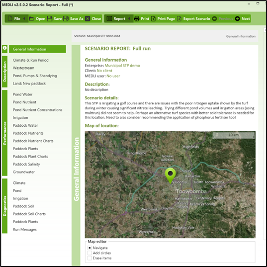
MEDLI model.
More information:
-
The Queensland Soil Monitoring (QSM) Program aims to provide a statistically rigorous baseline dataset on soil conditions to inform land managers of underlying changes in soil conditions due to land use or broader environmental change, such as climate change.
Currently, QSM covers the following categories in 37 sites:
- cereal cropping – dryland and irrigated
- sugar cane
- pastures – cleared and uncleared,
- forge cropping
- horticulture.
Soil properties are measured down to 60cm, capturing the main aspects of soil health, including soil pH, organic carbon and many other soil parameters.
This baseline data provides a foundation to inform land managers on likely changes in these soil properties related to management practice and climate change. At present, more sites are not anticipated to be added. The QSM team will assess existing sites over the next few years to monitor for change. Nonetheless, adding sites to address key needs is regularly considered. The QSM team has also been working with CSIRO to develop the National Soil Monitoring Program (NSMP) to ensure the best monitoring information for Queensland.
-

Soil sampling sites in SALI
The Soil and Land Information (SALI) database holds soil and land resource data from across Queensland, including:
- soil profile descriptions
- soil chemical data
- maps.
SALI contains soil data from nearly 120,000 sites across the state gathered from approximately 750 projects and datasets. The data is updated and maintained progressively as new data is added and new projects start.
The Queensland Globe provides access to all the data and maps. The Queensland Spatial Catalogue provides detailed GIS information and the Queensland Government Publications Portal provides access to land resource studies. Land managers, agronomists and soil scientists use this data to inform land management decisions.
Queensland State Soils Collection
Soil samples from many of the sites in SALI and other important samples provided by researchers are stored in the Queensland State Soils Collection (QSSC). The QSSC is an archive of more than 140,000 soil samples from across the state. It continues to grow and develop as a resource, with new soil sites added each year from soil scientists in Queensland.
The QSSC is available to scientists in the Queensland Government, universities and other research institutions to improve the efficiency of research and the development of land resource science for Queensland’s benefit.
Australian National Soil Information System
SALI data feeds into the Australian National Soil Information System (ANSIS), an outcome of the National Soil Strategy. ANSIS provides a seamless connection to the publicly available soil site data held within each state, providing a consistent format for users.
More information:
-
The Long Paddock is a Queensland Government initiative providing climate information to the community. The site offers access to rainfall and pasture outlooks and tools to support land management decision-making and planning for landholders, education, consultants and extension officers.
The Science and Technology Division of the Queensland Department of Energy and Climate operates the Long Paddock website with support from the Queensland Department of Agriculture and Fisheries.
The Queensland Future Climate Dashboard and Regional Explorer provide easy-to-use interfaces to high-resolution climate data and summary information. These online tools allow users to explore climate projection data for over 200 regions, three emissions scenarios (SSP1-2.6, SSP2-4.5 and SSP3-7.0), calendar seasons and time steps (2030, 2050, 2070 and 2090).
In addition to high spatial resolution (10km grid), the dashboard provides access to a wide range of climate variables, e.g. extreme events, in multiple formats, including maps, charts, tables and shapefiles to support further analysis and inform risk assessments.
Outcomes
Long Paddock includes information on the following:
- drought declarations
- drought and climate adaptation
- Southern Oscillation Index (used to assess the El Niño Southern Oscillation phenomenon)
- climate outlooks, weather and fire
- scientific information for landowners (SILO provides daily meteorological datasets in ready-to-use formats suitable for biophysical modelling, research and climate applications)
- AussieGRASS rainfall and pasture
- FORAGE (grazing science for property management)
- Queensland future climate
- Australia’s variable rainfall.