


BioCondition and Spatial BioCondition Framework
 © Queensland Government
The assessment of vegetation condition for biodiversity provides information to support biodiversity conservation and restoration, and natural resource management decision-making. It can be used to assess vegetation condition for threatened and non-threatened species and is a key requirement for existing and emerging natural capital accounting schemes and biodiversity offset markets.
BioCondition is a vegetation condition assessment framework that provides a measure of the capacity of a terrestrial ecosystem to maintain biodiversity values at a local or property scale. It is a site-based, quantitative and repeatable assessment procedure that provides a numeric score to reflect functional, through to dysfunctional, vegetation condition states biodiversity.
Since the SOE 2020 a program of work by the Queensland Herbarium and Biodiversity Science and Remote Sensing Centre, in partnership with others, has progressed to develop a method to map vegetation condition at the regional level.
The Spatial BioCondition (SBC) Framework aligns with Queensland’s Regional Ecosystem (RE) and BioCondition frameworks and complements regional ecosystem mapping and the Statewide Landcover and Trees Study to provide comprehensive mapping and reporting on vegetation extent and condition in Queensland.
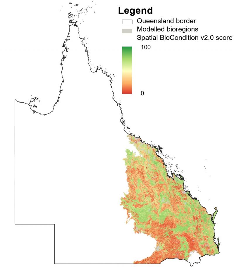
Spatial BioCondition is a modelling and mapping framework that is used to predict and map the condition of vegetation in most of Queensland’s regional ecosystems. Using machine learning to integrate site-based vegetation condition assessment methods and remote sensing land cover data, the framework predicts how well the vegetation maintains the biodiversity values in each ecosystem.
The current version of SBC(version 2.0) provides condition predictions for the year 2021 for the Brigalow Belt, Central Queensland Coast and Southeast Queensland bioregions (Figure 1). A Spatial BioCondition score has been generated for about 96% of the area covered by these three bioregions prior to masking exclusions. The accuracy of SBC predictions has been assessed using an independent field validation. Results indicated that agreement between the SBC predictions and the observed field data is about 70% with a mean absolute error of 13.4. SBC is intended to be used for regional scale applications. Given the resolution of the predictions, it may be useful at more localised scales but as with any predictive modelling, it is likely to have some limitations at some locations. The SBC team are currently working on extending the output to other bioregions and to increase model accuracy.
The following areas are excluded from the current map:
- regional ecosystems with insufficient training data to apply the framework
- marine, intertidal, native grassland, sedgeland, forbland and predominantly unvegetated ecosystems
- urban, suburban, commercial, and industrial areas including intensive use lakes, estuaries, canals, dams and reservoirs.